Hiking Trails in Cozumel

Please register or login

Welcome to ScubaBoard, the world's largest scuba diving community. Registration is not required to read the forums, but we encourage you to join. Joining has its benefits and enables you to participate in the discussions.

Benefits of registering include

  • Ability to post and comment on topics and discussions.
  • A Free photo gallery to share your dive photos with the world.
  • You can make this box go away

Joining is quick and easy. Log in or Register now!

Dear Mike,

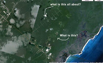
They stopped the ATV tours years ago, thank goodness. I don't know what turn around you are referring to but at Hanan the "road" now comes to a complete (face in the jungle) end and is VERY hard to turn around in. That dead end point is a little more than 6 KM from Mescalitos. The small Mayan structure I referred to is more or less 3.1 km from Mescalitos. El Castillo which is north of Hanan, and very worthy of a visit I have been to only by boat so my estimate of an additional 2 KM was no more than a wild ass guess.


Dave Dillehay
Aldora Divers

PS Don't end your hike at dusk or after as the mosquitos there will stop biting only after all the blood is gone!


ATV to me is genric name for off road vehicle. I think in Cozumel ATVs are what we call quads

quad-bikes-01.jpg


The tour we did in November was on more specifically what we call Razors or Mules

polaris_razor400.jpg


I think this was the tour we did

Cozumel RAZOR Jungle Buggy Tour - A Cozumel Tours Excursion

I don't have a picture of the ruins I am referring to. It was a low building set about 5 feet off of the 'turn around' which was just a loop in the trail (the trail keeps going), big enough for about 7-8 razors to turn off on and get off the main trail, the guides said this was as far as they were allowed to take commercial clients now due to restrictions by the government. It was almost exactly 5 miles by our speedo. (accurate? I don't know, it wasn't my Razor so I have no idea how accurate the speedo was)

The only other structure I saw between this ruin and back to Mescalitos was what looked to me to have been a more modern his/hers bathroom building that you could see coming around a turn sitting up from the beach but did not pass close enough on the trail to see it when you went by. It looked more like one of the 'slave houses' you see on Bonaire.

Something like this, but not as nice

2793862010104237032S600x600Q85.jpg
 
That might be the remains of the old "galleon" (that was its name) resturant which was open for all of 2-4 months and destroyed by Roxanne?? in 95 more or less. Its about one or so miles from Mescalitos.
 
That's probably what it is, sounds about right distance wise.

I definitly am rekindled in my quest to get to the north light house by hook or by crook. Especially now that I am hearing about El Castile too.

You can find a lot of references to the light house and El Castile on the internet, most of them are from 10 years ago.

If you look at google maps you can get down to the 2nd fines detail level on the area around Punta Molas and look around. Looks like there are some trials leading directly south from the light house and maybe a cenote on the west shore about 2 miles away from the light house.

On another tangent - anybody know what the area is to the east of the roads that head north off of Benito Juarez (the roads look like a tv antena) the area looks like cultivated fields?
 

Attachments

  • coz1.jpg
    coz1.jpg
    47.3 KB · Views: 191
  • coz2.jpg
    coz2.jpg
    56.1 KB · Views: 168
Last edited:
Based on the fine selection of spear guns on the back wall in the picture of Aqua Safari you have from 1967, we know how it go it's name. :D
 

Attachments

  • coz3.jpg
    coz3.jpg
    57 KB · Views: 1,048
The criss cross road pattern are the water pump access roads. Fresh water comes from the wells in the center of the island and you are seeing the roads to service the pumps.
 
Punta Molas Lighthouse
Castillo Real Ruin (north of hannan)
 
How far is the hike to Hannah beach from the point where the road stops near Mexcalitos? Did you say there are Hannah Beach is the place to snorkel where we wont' be beat up by the surf? How far is Rancho Ixpallbarco? They say there is Mayan Architect there?
 
How far is the hike to Hannah beach from the point where the road stops near Mexcalitos? Did you say there are Hannah Beach is the place to snorkel where we wont' be beat up by the surf? How far is Rancho Ixpallbarco? They say there is Mayan Architect there?


Here are some pics I took on a trip we made to Ha-Nan Bay back in 2001. Four of us were diving, the rest were snorkeling. I did not know the snorkelers. The bay is protected by the reef which lies about 300 meters off shore. It is calm, clear and unbelievably beautiful. I can tell you that from Mescalitos, the drive up a VERY rough road was about an hour. It was slow going. I have no info on Ixpallbarco. I'd be glad to answer any other questions you might have if I can. I have made other trips/dive trips over there as well. A little ways short of Ha-Nan there is another small beach area that is also beautiful. It however is not protected by a reef. Cozumel Aug. 03  Bob 173.jpg

IM000321.JPG

IM000323.JPG

IM000330.JPG

IM000331.JPG

IM000332.JPG

IM000336.JPG

IM000335.JPG
 
https://www.shearwater.com/products/perdix-ai/

Back
Top Bottom