Here Comes Hurricane Dean....!

Please register or login

Welcome to ScubaBoard, the world's largest scuba diving community. Registration is not required to read the forums, but we encourage you to join. Joining has its benefits and enables you to participate in the discussions.

Benefits of registering include

  • Ability to post and comment on topics and discussions.
  • A Free photo gallery to share your dive photos with the world.
  • You can make this box go away

Joining is quick and easy. Log in or Register now!

DandyDon

Colonoscopy Advocate
ScubaBoard Supporter
Messages
53,643
Reaction score
7,825
Location
One kilometer high on the Texas Central Plains
# of dives
500 - 999
Current projections are far short of my Cozumel plans on this map thru the 19th, altho I'd be challenged to head for anywhere in the Antilles today. Let's hope he's as wimpy as the previous 3. I think I read that the Pacific El Nino as disrupting the power of the Atlantic storms, or something like that. Two years ago, we were so much further thru the alphabet with Wilma occurring in October.
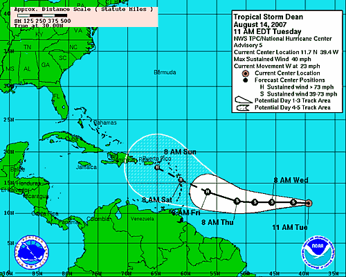
WTNT34 KNHC 141433
TCPAT4
BULLETIN
TROPICAL STORM DEAN ADVISORY NUMBER 5
NWS TPC/NATIONAL HURRICANE CENTER MIAMI FL AL042007
1100 AM AST TUE AUG 14 2007

...DEAN FORMS IN THE DEEP TROPICS...MIDWAY BETWEEN AFRICA AND THE
LESSER ANTILLES...

INTERESTS IN THE LESSER ANTILLES SHOULD MONITOR THE PROGRESS OF
DEAN.

AT 1100 AM AST...1500Z...THE CENTER OF TROPICAL STORM DEAN WAS
LOCATED NEAR LATITUDE 11.7 NORTH...LONGITUDE 39.4 WEST OR ABOUT 1030
MILES...1660 KM...WEST OF THE SOUTHERNMOST CAPE VERDE ISLANDS AND
ABOUT 1490 MILES...2400 KM...EAST OF THE LESSER ANTILLES.

DEAN IS MOVING TOWARD THE WEST NEAR 23 MPH...37 KM/HR...AND THIS
MOTION IS EXPECTED TO CONTINUE DURING THE NEXT 24 HOURS.

MAXIMUM SUSTAINED WINDS ARE NEAR 40 MPH...65 KM/HR...WITH HIGHER
GUSTS. SOME GRADUAL STRENGTHENING IS FORECAST DURING THE NEXT 24
HOURS.

TROPICAL STORM FORCE WINDS EXTEND OUTWARD UP TO 35 MILES...55 KM
MAINLY TO THE NORTH OF THE CENTER.

ESTIMATED MINIMUM CENTRAL PRESSURE IS 1004 MB...29.65 INCHES.

REPEATING THE 1100 AM AST POSITION...11.7 N...39.4 W. MOVEMENT
TOWARD...WEST NEAR 23 MPH. MAXIMUM SUSTAINED WINDS...40 MPH.
MINIMUM CENTRAL PRESSURE...1004 MB.

THE NEXT ADVISORY WILL BE ISSUED BY THE NATIONAL HURRICANE CENTER AT
500 PM AST.

$$
FORECASTER AVILA

143523W_sm.gif


Yeah, I know - I am too. May leave early, but 5 day forecasts are very iffy...!

Four storms around the globe...
In the Gulf of Mexico, Tropical depression Five formed last night, and then was upgraded to Tropical Storm Erin on Wednesday. The storm is moving northwest toward the southeastern Texas Coast.

Conditions appear favorable for Tropical Storm Erin to be a flooding rain threat into Saturday morning.

The current forecast track brings Erin to the southern Texas Coast on Thursday, but the impacts will be felt along all of the Texas Coast, from Brownsville, through Corpus Christi and Houston, to Lake Charles, LA in the form of squally rain.

On Friday the storm will slowly spin into south central Texas bringing a swath of potentially heavy rain with a risk for flooding and flash flooding in an area very wet from summer storms.

The rain will also swell streams and rivers like the Nueces River (northwest of Corpus Christi) and Guadalupe River Near Bloomington (near Victoria)back into moderate to major flood stages into the weekend. Extreme caution is advised if you live or travel near these rivers.

Through Thursday evening heavy showers and thunderstorms will bring heavy rainfall of 3 to 5 inches over South Texas, including areas from Brownsville to Corpus Christi, with as much as 2 to 4 inches from Houston to Lake Charles. Some localized areas could experience 8 inches of rain or more by Saturday.

Gusty winds will also be on the increase, along with rough surf, especially along the southern Texas Coast. That being said, wind impacts will likely be far less compared to the heavy rain impact.

Meanwhile, our second area of concern, Tropical Storm Dean (65 mph), continues to move quickly west in the Atlantic.

Dean is now steadily intensifying and is forecast to become a hurricane by Thursday night or early Friday, and should be threatening the Lesser Antilles as early as Friday. A hurricane watch may be posted tonight or early Thursday morning for the the Lesser Antilles. From there, Dean should continue westward into the Caribbean and has the potential to continue to increase in strength and threaten Hispaniola to Jamaica and the Cayman Islands.

It is too early to tell what, if any, impacts Dean will have on the United States but all along the East to Gulf Coast will want to keep monitoring Dean through the weekend into next week.

Flossie has been downgraded to a tropical storm as it moves underneath the Hawaiian Island Chain and is forecast to slowly weaken in intensity. So far it has been mainly high surf and some locally heav rain near South Point that impacted Hawaii, and mainly on the Big Island. Good news for at one point Flossie was a major hurricane category 4 that quickly weakened to a tropical storm when it approached weakened to a tropical storm when it approached the Big Island.

The weather will improve nicely so don't worry if you vacation plans take you to the Land of Paradise the next few days.

In the western Pacific all eyes are watching Super Typhoon Sepat east of the northern Philippines. It is forecast to bring heavy flooding rain to the northern end of Luzon with very high dangerous surf and then head toward the island nation of Taiwan as a major Typhoon with damaging wind and flooding rain a real threat in a few days. The track then takes it into eastern China with a concern for more flooding
 
looks like our choices are dean spinning up into a category 4 and taking out cozumel or spinning up into a category 5 into the gulf and heading for the gulf states:

at200704_5day.gif


at200704_model.gif


dean04l.2007081612_anim.gif


Its looking like a Wilma, Ivan, Rita, Katrina storm. Unless it enters the Gulf, finds some cooler water and some wind shear and calms down a lot before hitting land...
 
The GFDL and UKMET tracks concern me the most. Texas has had record rainfall all year. When Rita hit, at least the lakes and the soil could sop up some of the water. Not this year. I have family in New Orleans and Houston.

This is going to be one to watch closely.

TwoBit
 
And my oh my is Dean flying
 
Yeah, I'm on Cozumel now, maybe should have left sooner...?
 
The hurricane is a bigger threat than ever, and everyone is evacuating as possible.

I booked a flight out on Monday last night - took an hour, then went out on a boat trip this morning, while the others stayed behind to depart or to make their escape arrangements. I think I got my reservation changed to a new flight just added by Cont out of Cancun tomorrow. It's a hassle, but it'll be me out a day early, home a day earlier. Got to leave the hotel around 3am for the 5am ferry, then get a bus to Cancun to check in early, blah blah blah - gonna be a loooong day.

OMG, a cab just delivered 4 tourists who just arrived?! I suggested they get back on the cab and run for it like the rest of us, but they didn't want to hear it. I had to offer that suggestion; bet they remember it when they're hunkered down in a sealed room listening to H.Dean howling.
__________________
 

Back
Top Bottom