I-90 heads for the Greater Antilles

Please register or login

Welcome to ScubaBoard, the world's largest scuba diving community. Registration is not required to read the forums, but we encourage you to join. Joining has its benefits and enables you to participate in the discussions.

Benefits of registering include

  • Ability to post and comment on topics and discussions.
  • A Free photo gallery to share your dive photos with the world.
  • You can make this box go away

Joining is quick and easy. Log in or Register now!

DandyDon

Colonoscopy Advocate
ScubaBoard Supporter
Messages
53,663
Reaction score
7,837
Location
One kilometer high on the Texas Central Plains
# of dives
500 - 999
Looks like rain at least, flooding, and maybe a real storm later.....

Posted by: JeffMasters, 9:58 AM EDT on October 25, 2007
A surface low pressure system (90L) just east of Puerto Rico is moving to the west at 5-10 mph. This low is entangled with an upper-level low pressure system that is bringing about 30 knots of wind shear, so no development is likely today. Long range radar out of Puerto Rico shows bands of heavy rain hitting the islands and surrounding waters, but these bands are not well-organized. Satellite loops show most of the heavy thunderstorm activity is to the northeast of the low's center of circulation, and high wind shear is keeping this thunderstorm activity disorganized. This morning's QuikSCAT pass missed 90L.

The surface low is expected to separate from the upper level low tonight and move west-southwest or southwest across Puerto Rico, bringing the threat of heavy rain and flooding to the island. Recent rains have left large areas of interior and western Puerto Rico at or near saturation, and mudslides were reported yesterday in Utuado. Flooding problems and mudslides are likely across Puerto Rico and the Virgin Islands Friday and Saturday, and this is shaping up to be the most significant rain event of the fall wet season thus far for Puerto Rico.

On Friday and Saturday, 90L will move westward along or just south of Hispaniola, bringing heavy rain, flash flooding, and possible mudslides to that island. The ECMWF and NOGAPS models predict that wind shear will drop to 10-20 knots by Friday night, which may allow some slow development of the disturbance if the center remains over water. The GFS model keeps wind shear 20-30 knots through the period, and does not develop 90L. By Saturday, the storm will near Jamaica, and the ECMWF and NOGAPS models predict a tropical depression will form by Sunday. Steering currents grow weak on Monday, and the storm could stall out for many days in the Western Caribbean, in an area of low wind shear and high heat content waters. This may allow the system to intensify into a hurricane. The eventual fate of this system is highly uncertain, since steering currents will be so weak. Those of you planning to travel to the Western Caribbean next week should keep a close watch on this system. NHC has not scheduled any flights into 90L yet.

It is possible that wind shear and passage over the islands will sufficiently disrupt this disturbance so that it does not develop. However, surface pressures have fallen 2-3 mb over most of the Western Caribbean the past two days, and there is a good chance that a new area of disturbed weather will develop. One such disturbance formed yesterday south of Haiti, but has since dissipated. Unsettled rainy weather can be expected to affect much of the Western Caribbean over the coming week.

at200790_model.gif
 
Upgraded to TS #16...

at200716.gif
 
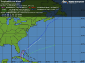
TS Noel has killed at least 8 - head for Bahamas next...

at200716.gif
 

Attachments

  • Noel.gif
    Noel.gif
    33.4 KB · Views: 66
I suppose I have a unique perspective on Noel, as we have been sitting in the middle of it for several days now. I am on the Caribbean Explorer I, currently parked in Georgetown harbor at Great Exuma in the Bahamas, and we have been sitting here since Monday. Rain and wind, wind and rain, etc, etc. Nothing is moving around here, and the town is shut down tight with about a foot of water over the roads in several places. Diving? Well, we got in about a half dozen dives off Long Island before the weather drove us back to Georgetown. I wonder if I should talk to PADI about a new diving specialty- Storm Diver... Well, I guess diving is shot for this trip, and now we are starting to worry about the status of our flights out on Saturday. Nothing is flying here so far, and the durn thing is supposed to be leaving this area later today, but then thats what they said about it yesterday... I guess things could be worse- we could be on one of those little Blackbeard boats:11: At least we have the comforts of a big dedicated dive yacht, and they have been working to ease things as much as they can, but still-:shakehead: Well I suppose I should take this over to the liveaboard forum, as I am starting to get off topic for this spot. I will post more later if this internet connection I found holds up. Woody
 
Thanks for that report, Woody. Really good that you were on the Explorer and not a tiny Blackbeards, but still sad to lose most of your dive trip. It's happened to me a few times, hope your trip insurance pays some.

Noel upgraded to Hurricane Cat-1, but headed away from the islands...

I finally noticed that the maps using source codes from the weather site change each day, so there is no point in including it here again. See above.

Posted by: JeffMasters, 9:58 AM EDT on November 02, 2007
Hurricane Noel pulled off a surprising burst of intensification last night despite 30 knots of wind shear. The storm's pressure dropped from 993 mb to 981 mb in just a few hours, and the winds cranked up to 80 mph. Noel is the first November hurricane in the Atlantic since Hurricane Michelle of 2001. Fortunately, Noel's intensification burst came after the storm had cleared the Bahama Islands, and wind damage was relatively minor in the islands. The latest Hurricane Hunter eye report at 8am EDT found the pressure holding steady at 981 mb, and weaker surface winds, 70-75 mph.

Noel the hurricane becomes Noel the 'Noreaster
Noel will brush Cape Hatteras, North Carolina, today, bringing winds near tropical storm force and a few rain bands. Strong northerly winds are expected to cause coastal flooding inside Pamlico Sound, with water levels 4-6 feet above normal. Winds at the Diamond Shoals buoy off the coast of Cape Hatteras were sustained at 40 mph, gusting to 47 mph, at 10am EDT. Seas were 15 feet, and 10-12 foot breakers are expected along the Outer Banks today. Noel has expanded significantly in size over the past 24 hours, and is bringing tropical storm force winds over a huge area of ocean (Figure 1). As Noel approaches New England on Saturday, the hurricane will make the transition to a powerful 'Noreaster, as cold air spills into the storm from the northwest. Noel's wind field is expected to expand farther, and the storm will maintain its intensity. Sustained winds of tropical storm force (39 mph) are likely along eastern Long Island and the coasts of Rhode Island, Massachusetts, New Hampshire, Maine, and Nova Scotia. The latest (06Z) runs of the GFDL and HWRF models intensify Noel to a 954 mb 'Noreaster, and bring sustained winds of hurricane force (75 mph) to Cape Cod and Nantucket. The ECMWF and NOGAPS models also bring Noel quite close to Cape Cod, and foresee a landfall near the Maine/Nova Scotia border. The UKMET and GFS models are farther east, bringing Noel to the western or central coast of Nova Scotia. Due to the wide wind field of Noel, both Massachusetts and Nova Scotia may see hurricane force winds. Due to the cold air invading Noel from the west, the western side of the storm will be the rainy side, and coastal Massachusetts can expect 2-6 inches of rain. About 1-3 inches are likely for Nova Scotia.
 

Back
Top Bottom