I-94 Aiming at Lesser Antilles

Please register or login

Welcome to ScubaBoard, the world's largest scuba diving community. Registration is not required to read the forums, but we encourage you to join. Joining has its benefits and enables you to participate in the discussions.

Benefits of registering include

  • Ability to post and comment on topics and discussions.
  • A Free photo gallery to share your dive photos with the world.
  • You can make this box go away

Joining is quick and easy. Log in or Register now!

DandyDon

Colonoscopy Advocate
ScubaBoard Supporter
Messages
53,645
Reaction score
7,825
Location
One kilometer high on the Texas Central Plains
# of dives
500 - 999
This area of disturbed weather has the potential for tropical development.
 

Attachments

  • I94.gif
    I94.gif
    33.4 KB · Views: 84
For now....
  • I-94 is looking at Cozumel and the Yucatan with 20-50% probability of tropical cyclone formation within 48 hours;
  • I-95 is headed into Central America with less than 20% probability of tropical cyclone formation within 48 hours;
  • I-96 is headed along the Carolinas' coasts with 20-50% probability of tropical cyclone formation within 48 hours; and
  • "Bertha is still hanging around the central Atlantic and at this point is becoming one of the longest-lived tropical storms on record. She is already the longest-lived July storm on record." Dr.Jeff Masters

Special note from NHC...
NHC Forecast Model Background and Information

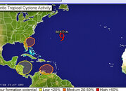
The National Hurricane Center (NHC) does not generate a graphic of the models it uses to produce its forecasts. We do this because our past experience indicates such plots have confused users and detracted from our final message, which is producing official tropical cyclone forecasts and advisories. Some users have also become too reliant in the individual forecast scenarios presented by the many model forecast lines, some of which have little or no chance of being correct. This is not the message the NHC wants to send. (Please read our Mission and Vision).

There are also some logistical constraints. There are dozens of potential tracks deriving from all of the individual models, the various model ensemble members, etc. It would be difficult to decide which to show and we could not display them all clearly. Also, some models are only available every 12 hours, rather than every 6 hours, which leads to further complication of showing the data. We do offer the following links for background information on some of the models the NHC consults in making official forecasts.
 

Attachments

  • i-94.gif
    i-94.gif
    34.7 KB · Views: 78
  • i-95.gif
    i-95.gif
    28.3 KB · Views: 70
  • i-96.gif
    i-96.gif
    28.5 KB · Views: 42
  • Screen01_edited.JPG
    Screen01_edited.JPG
    228.1 KB · Views: 42
  • two_atl-thumb-400x325.gif
    two_atl-thumb-400x325.gif
    74.2 KB · Views: 70
I-94 seems more focused on the Yucatan, with I-95 still intent on coming ashore on Guatemala and I-96 raking the Carolinas.
 

Attachments

  • i-94.gif
    i-94.gif
    35 KB · Views: 59
  • North Atl.gif
    North Atl.gif
    80.3 KB · Views: 67
  • Screen02_edited (Small).JPG
    Screen02_edited (Small).JPG
    53.9 KB · Views: 53
Looks even more like a Sunday Cozumel area landing and Dr Masters expects it to be a Tropical Depression by Saturday. http://www.wunderground.com/blog/JeffMasters/comment.html?entrynum=989&tstamp=200807
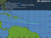
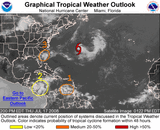
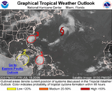
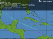
Caribbean disturbance 94L
A well-organized disturbance in the Central Caribbean (94L) is bringing heavy rain and gusty winds to Haiti and Jamaica tonight. This afternoon's Hurricane Hunter flight was unable to find a closed surface circulation, and this evening's 6:51 pm EDT QuikSCAT pass also shows no surface circulation. An upper-level cold low centered over Cuba is bringing about 20 knots of wind shear to the northern portion of 94L, but the southern portion of the disturbance is under only about 10 knots of wind shear.

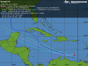
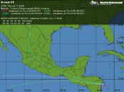
The upper-level low is forecast to slide westward and weaken over the next two days, bringing low wind shear of 5-10 knots over the disturbance Saturday and Sunday. The low shear combined with the warm (28.5°C) water of the Western Caribbean should allow 94L to finally organize into a tropical depression as early as Saturday afternoon. NHC is giving 94L a high (>50% chance) of developing into a tropical depression by Sunday morning. Another Hurricane Hunter mission is scheduled to fly into 94L at 2 pm EDT Saturday. The disturbance has time to potentially strengthen into a tropical storm with 50 mph winds before coming ashore on the Yucatan Peninsula sometime between Sunday night and Monday afternoon. Passage over the Yucatan will no doubt significantly disrupt what should be a relatively weak system, and it is unclear what threat, if any, the storm will pose to the Gulf of Mexico coast. Once it does cross into the Gulf, wind shear should be low enough to permit development.

Current models, subject to change...
[c]
52fiwz.jpg

[/c]
Click thumb for larger map
 

Attachments

  • I-94.gif
    I-94.gif
    36.8 KB · Views: 69
Last edited:
Now upgraded and known as Tropical Storm Dolly - veering south of Cozumel maybe.

Tropical Storm Dolly.gif Tropical Storm Dolly  2.gif TS Dolly.jpg
 
Too bad I can't change the thread title, as I don't guess most would connect I-94 and Hurricane Dolly as the same storm. Looks like she's is gonnnnnne for Coz and headed for the Rio Grande Valley. Hope she just delivers some nice rains that refill the reservoirs, but she is projected to make Hurricane status now. Cat-1 is low lever, but still a Cane...
 

Attachments

  • TS Dolly.gif
    TS Dolly.gif
    31.3 KB · Views: 51
  • TS Dolly 2.gif
    TS Dolly 2.gif
    30 KB · Views: 66
I doubt that there will be any diving around South Padre Wednesday, maybe Thursday - with low viz? Cat-1 is yet a hurricane. Best wishes to all there...

qrm7uq.gif


2qu80ac.gif
 
Ooops - She made Cat-2

2553ujm.jpg


2nhgthf.gif
 
https://www.shearwater.com/products/swift/

Back
Top Bottom