- Messages
- 53,645
- Reaction score
- 7,825
- # of dives
- 500 - 999
I-96 has been there and on this track but TD-3 just formed close-by.
JeffMasters, 11:26 PM EDT on July 18, 2008 Wunder Blog : Weather Underground
JeffMasters, 11:26 PM EDT on July 18, 2008 Wunder Blog : Weather Underground
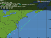
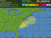
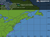
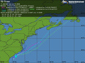
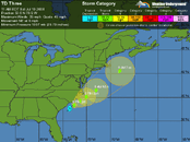
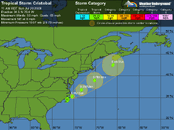
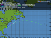
Tropical Depression Three has formed off the Southeast U.S. coast. Charleston, SC long range radar shows the slow development of a solid spiral band of thunderstorms to the southeast of the center, away from land. The storm is over waters of marginal warmth, about 27°C, a degree above the threshold of 26°C needed to sustain a tropical storm. The warm waters are very shallow, and the Tropical Cyclone Heat Potential is near zero, meaning we're unlikely to see rapid intensification of TD 3. Wind shear is about 15 knots over the storm, and is forecast to remain 10-15 knots over the next two days. There is some dry air over the Southeast U.S. that may get entrained into TD 3's circulation. TD 3 could intensify into a weak tropical storm, if the center manages to remain over water. None of the models forecast that TD 3 will intensify beyond a 50 mph tropical storm, and this is a reasonable forecast, due to the relatively cool water temperatures, moderate wind shear, and the presence of dry air nearby. Coastal areas of North Carolina are likely to get heavy rains from TD 3, but it remains to be seen if these rains will penetrate far enough inland to significantly alleviate drought conditions over the state. Heavy rains may also develop over South Carolina, but the main rain will probably remain offshore as the storm passes that state. TD 3 is unlikely to bring heavy rain to any other states, with the possible exception of Cape Cod and Nantucket, Massachusetts Monday/Tuesday.