


- Messages
- 53,643
- Reaction score
- 7,825
- # of dives
- 500 - 999
From Tropical Weather : Weather Underground
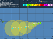
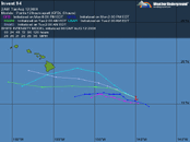
With the inhabited islands of Hawaii being around 155-160 West by 20 North...
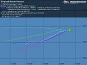
I-95 has potential for heading that way even tho it is well East at 115 West;
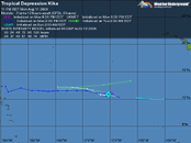
Tropical Depression Kika is in the neighborhood at 170 West by 10 North and no clear indication on path;
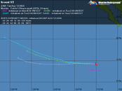
But Tropical Storm Hernan is around 132 West by 18 North with some indication of possibly heading for The Islands;
And I-94 is at 145 West by 15 North also with indication of possibly heading there.
Editing: The advisories are not very worrisome...
With the inhabited islands of Hawaii being around 155-160 West by 20 North...
I-95 has potential for heading that way even tho it is well East at 115 West;
Tropical Depression Kika is in the neighborhood at 170 West by 10 North and no clear indication on path;
But Tropical Storm Hernan is around 132 West by 18 North with some indication of possibly heading for The Islands;
And I-94 is at 145 West by 15 North also with indication of possibly heading there.
Editing: The advisories are not very worrisome...
For the central North Pacific...between 140w and 180
1. The remnants of former tropical cyclone Kika are located 1150
miles southwest of Honolulu...and are moving to the west at 15 mph.
Redevelopment is not expected before it crosses the dateline into
the northwest Pacific on Wednesday.
2. A low level circulation devoid of deep convection is located 650
miles east southeast of Hilo...and is moving to the west at 10 mph.
This circulation is located over cool water...and development is not
expected during the next 48 hours.
Elsewhere...no tropical cyclones are expected through early Thursday
morning.
For the eastern North Pacific...east of 140 degrees west longitude..
The National Hurricane Center is issuing advisories on Tropical
Storm Hernan...located about 1505 miles west of the southern tip of
Baja California.
Showers and thunderstorms associated with an area of low pressure
located about 200 miles south-southwest of Acapulco Mexico are
currently disorganized. Development of this system...if any...is
expected to be slow to occur as it moves west-northwestward at 10
to 15 mph.
Thunderstorms have increased in association with an area of low
pressure located about 800 miles west-southwest of Manzanillo
Mexico. While upper-level winds are only marginally favorable for
development...this system could become a tropical depression during
the next day or so as it moves west-southwestward at 10 to 15 mph.
Elsewhere...tropical cyclone formation is not expected during the
next 48 hours.
Attachments
Last edited:
