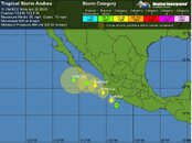
statement as of 11:00 pm pdt on june 22, 2009
...andres getting closer to the southwestern coast of mexico...
A hurricane warning remains in effect for the southwestern coast of
mexico from punto san telmo to cabo corrientes. A hurricane warning
means that hurricane conditions are expected somewhere within the
warning area within 24 hours. Preparations to protect life and
property should be rushed to completion.
A tropical storm warning and a hurricane watch remain in effect for
the southwestern coast of mexico from lazaro cardenas to punto san
telmo. A tropical storm warning means that tropical storm
conditions are expected somewhere within the warning area within 24
hours. A hurricane watch means that hurricane conditions are
possible within the watch area...generally within 36 hours.
Interests elsewhere along the southwestern coast of mexico should
monitor the progress of andres.
For storm information specific to your area...please monitor
products issued by your national meteorological service.
At 1100 pm pdt...0600 utc...the center of tropical storm andres was
located near latitude 17.2 north...longitude 103.2 west or about 160
miles...260 km...southeast of manzanillo mexico.
Andres is moving toward the northwest near 8 mph...13 km/hr...and
this general motion is expected to continue for the next 24 to 36
hours with a slight increase in forward speed. On the forecast
track... Andres should pass very close to...or over...the
southwestern coast of mexico within the warning area on tuesday.
Maximum sustained winds are near 65 mph...100 km/hr...with
higher gusts. Andres is forecast to become a hurricane on tuesday.
Tropical storm force winds extend outward up to 70 miles...110 km
from the center.
Estimated minimum central pressure is 994 mb...29.35 inches.
Andres is expected to produce total rain accumulations of 4 to 8
inches over portions of west-central mexico...with possible isolated
maximum amounts of 12 inches.
Coastal storm surge flooding of 1 to 3 feet above normal tide
levels...along with large and dangerous battering waves...are
possible in the warning area.
...summary of 1100 pm pdt information...
Location...17.2n 103.2w
maximum sustained winds...65 mph
present movement...northwest or 320 degrees at 8 mph
minimum central pressure...994 mb
the next advisory will be issued by the national
hurricane center at 200 am pdt.
$$
forecaster pasch


