"Invest 96L in the western Caribbean sea, bears watching closely"

Please register or login

Welcome to ScubaBoard, the world's largest scuba diving community. Registration is not required to read the forums, but we encourage you to join. Joining has its benefits and enables you to participate in the discussions.

Benefits of registering include

  • Ability to post and comment on topics and discussions.
  • A Free photo gallery to share your dive photos with the world.
  • You can make this box go away

Joining is quick and easy. Log in or Register now!

DandyDon

Colonoscopy Advocate
ScubaBoard Supporter
Messages
53,643
Reaction score
7,825
Location
One kilometer high on the Texas Central Plains
# of dives
500 - 999
Sounds like Alex repeat...

From Wunder Blog : Weather Underground
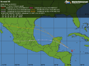
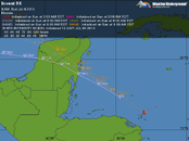
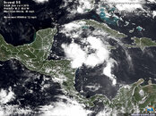
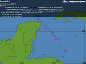
Invest 96L is in the western Caribbean sea and bears watching closely. Earlier in the morning, the convection was all on the east side of the circulation center, but thunderstorms have developed on the southwest side. According to the CIMMS wind shear analysis, 96L is on the outskirts of a low wind shear region just east of the Yucatan peninsula. It's also over warm SST's (>29 deg C), so it could intensify. NHC gives it a 20% chance of becoming a tropical cyclone in the next 48 hours. Computer models have 96L going through the Yucatan Channel then turning left and making landfall somewhere near the Rio Grande.
 

Attachments

  • at201096_model.gif
    at201096_model.gif
    30.7 KB · Views: 106
  • Invest 96 b.gif
    Invest 96 b.gif
    29.6 KB · Views: 69
  • Invest 96 c.jpg
    Invest 96 c.jpg
    160.2 KB · Views: 47
Models shifted more north in the past few hours. They're now sending it smack over Coz, then NOGAPS take it north, while the others curve back to roughly Alex's track.
 
Models shifted more north in the past few hours. They're now sending it smack over Coz, then NOGAPS take it north, while the others curve back to roughly Alex's track.
Hoping it doesn't develop to more than some thunderstorms. Dr.Masters said that Alex killed enough Mexicans that the name could be retired but Mexico doesn't usually ask for such.
 

Attachments

  • at201096_model_zoom.gif
    at201096_model_zoom.gif
    32.2 KB · Views: 158
Hoping it doesn't develop to more than some thunderstorms. Dr.Masters said that Alex killed enough Mexicans that the name could be retired but Mexico doesn't usually ask for such.

Max the models intensify to is tropical storm strength (50mph).

There's also two other areas that NHC is watching in addition to I95/I96 that haven't gotten an Invest number yet:

two_atl.gif
 
Now on top of Cozumel with port closed. I'll post the self updating maps here since no one else is discussing it here...

at201096_model.gif

Even Lubbock TX incurred flooding from Alex and the remnants are still raining here some. My daughter's sis-in-law ruined her SUV engine Saturday night, but after last week's 1,000 mile trip with her's as one of the two vehicles - having seen her driving, I'm glad she and her kids didn't float off into a playa lake. Flooding is the most deadly factor of any of these storms.

All of the models take this one over the western Gulf torward Texas or Mexico, but Master's is thinking more northerly, with intensity building this week.

at201096_model_zoom.gif
 
I'm arriving there Wed (7/7) - should I not go? My plan was to dive Wed PM to Saturday PM, leaving Sunday. Do you reckon it'll be dangerous just to be there?


Cheers,

Andre
 
I'm arriving there Wed (7/7) - should I not go? My plan was to dive Wed PM to Saturday PM, leaving Sunday. Do you reckon it'll be dangerous just to be there?


Cheers,

Andre
Dangerous? No way! I should have canceled once with a Cat-5 hurricane headed that way (I was too eager, betting it would serve even tho all the models said otherwise), and I did leave after a few days - but this is totally different, gone actually if your "there" is Cozumel...?

Look at the self updating maps in the last post and see that it has moved onto the peninsula, more or less where Chichen Itza is, away from Coz and moving away still, as well as losing power over land.

There may be some lingering thunderstorms, but no biggie - I'd go! Here is the Coz forecast for the week. Cozumel, Mexico Forecast : Weather Underground

Go and have a great trip...! :pilot:
 
Thanks! It does look much better than I had imagined. Trip report coming soon!!
 
I'm arriving there Wed (7/7) - should I not go? My plan was to dive Wed PM to Saturday PM, leaving Sunday. Do you reckon it'll be dangerous just to be there?


Cheers,

Andre

Its gone from Coz, and there's nothing spinning up in the neighborhood, so you should have nice weather.

And, as far as I96 goes, it might disrupt the BP oil collection efforts a little bit, but its traveling over the cold water that Alex chewed up and its unlikely to even hit tropical depression status.
 
https://www.shearwater.com/products/perdix-ai/

Back
Top Bottom