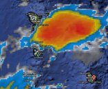
Invest 95 threatens Caribbean

Please register or login

Welcome to ScubaBoard, the world's largest scuba diving community. Registration is not required to read the forums, but we encourage you to join. Joining has its benefits and enables you to participate in the discussions.

Benefits of registering include

  • Ability to post and comment on topics and discussions.
  • A Free photo gallery to share your dive photos with the world.
  • You can make this box go away

Joining is quick and easy. Log in or Register now!

DandyDon

Colonoscopy Advocate
ScubaBoard Supporter
Messages
53,643
Reaction score
7,825
Location
One kilometer high on the Texas Central Plains
# of dives
500 - 999
It's not too late. We've seen them into January, but maybe it will veer away. It is possible that it could hit the Lesser Antilles already hit hard earlier this year tho, and move on across the playground? From Tropical Storm: Computer Model Hurricane Forecasts : Weather Underground

Map should self update

at201095_model.gif

 
It may not have staying power, but it's still active between Barbados and Martinique.

click this one: i95.JPG

at201095_model_zoom.gif
 
000
abnt20 knhc 212049
twoat
special tropical weather outlook
nws tpc/national hurricane center miami fl
350 pm est tue dec 21 2010

for the north atlantic...caribbean sea and the gulf of mexico...

A small low pressure system located just west of barbados is
producing disorganized showers and thunderstorms. Upper-level winds
are not conducive for significant development to occur...and
conditions are expected to remain unfavorable for tropical cyclone
formation over the next several days. There is a low chance...near
0 percent...of this system becoming a tropical cyclone during the
next 48 hours as it moves toward the west-northwest or northwest at
10 to 15 mph. However...this system will enhance rainfall and winds
across portions of the windward islands today and across much of
the lesser antilles tomorrow.

This will be the last special tropical weather outlook issued on
this disturbance. Additional information on this system can be
found in high seas forecasts issued by the national weather
service...under awips header nfdhsfat1 and wmo header fznt01 kwbc.

Elsewhere...tropical cyclone formation is not expected during the
next 48 hours.

$$
forecaster stewart
 
https://www.shearwater.com/products/teric/

Back
Top Bottom