In general the west/north side of Roatan is the leeward side, and the south is the windward.
Mostly kind-of sorta' correct.
The North side is
absolutely the leeward side. This means that "prevailing" (normal, usual) winds come from elsewhere, in this case they blow from the ESE.
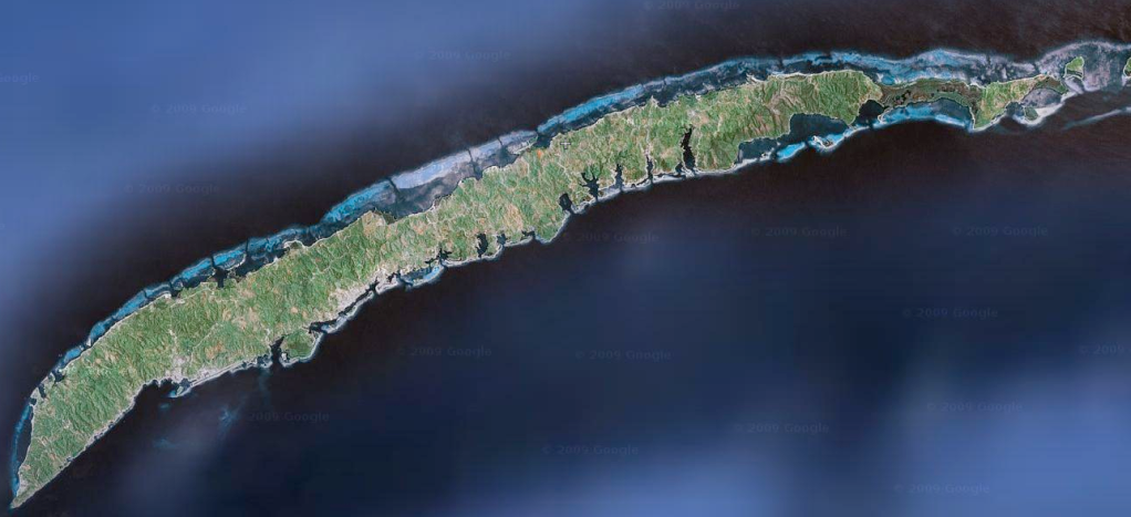
Roatan is odd in many ways, not the least of which is it's shape, roughly 5 x 20 miles, but more importantly, it's position on the compass. Most maps show it horizontal. If you look at the reality, the long narrow island is on a line of (roughly) SW to NE orientation. This misunderstood fact plays a HUGE part in Roatan's micro climates.
Taking
the leeward/windward fact at face value without localized interpretation is a simplistic path to an erroneous generalization. It is not correct to simply state that the North/West of Roatan is "calmer". There are a whole lot of exceptions and asterisks to that otherwise "leeward" assumption.
A simple comparison of reef structures as they vary greatly between these two zones will paint a vivid picture of the distinctions. Because of the windward/leedward, Roatan's North/West has the greatest number of flat calm days. Why isn't the reef close in, shallow and teeming with soft corals and delicate little critters? If it's the flat side, why is the reef structure deep, rather stark and far off shore? It is because of the wind and waves when it isn't flat... during the pounding from storms.

The N/W is the area that gets it's butt kicked on a regular basis from September through March. That's what causes the reef to have that battered shape. Look at the recently placed wrecks. They are at 115' and deeper and now lay in tatters.
Contrast all of this to the South side where there is usually a chop and breeze. That's why purpose-designed boats look the way they do over there. Round bottomed boats....
The South side reef, again- due to weather, is close to shore, laden with delicate stuff, and very shallow. There are two placed wrecks, they are in 35 to 65 feet and perfectly intact.
Real shore dives as the OP queried... with interesting stuff in the protected shallows?
South side.
Bigger dive ops on the North/West buy the boats that are perfect for their sea condiyions... Deep Vee hulls. The moment you grasp the importance of that indicator, you'll have the epiphany. These boast are selected because of... well- it aint calm waters, folks. Dive operations , if they have the financial depth, will completely migrate their dive operations to the South side regularly when the North side closes down. Some resorts (AKR) will bus you around and go to their South side dock space that they maintain for the inevitable requirement. Some make you ride around and back (not fun), and others simply shrug their shoulders and tell you to go drink.
The very few South side based dive operations (all AI so far), can take guests out every day, no matter what the weather. It is essentially a 365 schedule with few exceptions. They only go to the North and West on occasional full day trips.
So yes,
the South side is indeed the windward side, with the North and West laying in the common shadow... becoming the leeward... but you must understand how the Calendar affects the weather.
Roatan is located South West of the farthest left hand
red dot • thingie....
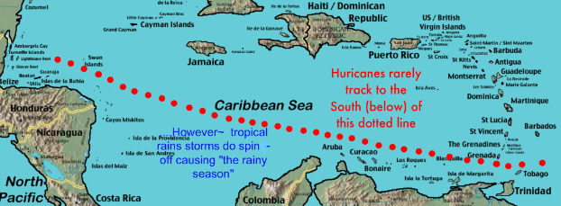
The
September thru November time frame is a season of tropical storms (including hurricanes) that usually track across the map to the North, rarely getting much closer than Belize, 90 miles North. This path, as far away as 90 miles may seem, exposes the North/West Roatan environs to heavy wind and lashing waves.
November through March the same kind of pounding can occur in this area because of "Northers", usually seen after we note cold weather descending Southward in the US from the Arctic.
So more precisely stated: Roatan's
Leeward side is the North and West. Roatan's
Storm Leeward is the South side.
Check you calendar, understand the seasons.


