Navigating Via GPS

Please register or login

Welcome to ScubaBoard, the world's largest scuba diving community. Registration is not required to read the forums, but we encourage you to join. Joining has its benefits and enables you to participate in the discussions.

Benefits of registering include

  • Ability to post and comment on topics and discussions.
  • A Free photo gallery to share your dive photos with the world.
  • You can make this box go away

Joining is quick and easy. Log in or Register now!

azhar

Registered
Messages
45
Reaction score
10
Location
Karachi, Pakistan
# of dives
25 - 49
I got a question which may sound very basic or silly but here it goes....I got point fix coordinates to a dive site, usually a GPS is accurate within +/-20m. I get to the spot, I am 80ft above the target and the boat drifts ... Anchor requires time to sink ... And visibility down there is usually like 5m or less ...If I anchor 10m off and I will never find the wreck.

So is there is a specific way to mark and also a specific way/technique to approach and anchor? How to navigate a small deep target? Please note I m not using a depth sounder or any type of imaging. Basic Etrex type GPS only.

Thank's
 
If you are talking about a wreck which is on sand, then use a reef anchor. This will only hook into the wreck, it will not dig into the sand. Add lead to the anchor (pour inside) so it sinks quicker. The other way is to go upwind (or up current) of the GPS mark and drop there and drag back onto it.

In my experience, GPS is now accurate to about 5 to 10 metres. However, of course you need accurate GPS marks in the first place.

Hope this helps.
 
Put buoy with weight in the water and calculate direction and speed of drift/current utilizing the GPS. Use these numbers to determine when to drop the anchor (example: 5m per minute SSW or a bearing designation).

We use this technique to hit smaller targets in strong current 300ft down on "hot drops".
 
Can you recommend any website or detailed reading material on this technique? I want to find out how to hit small targets in deep water using only GPS coordinates!
 
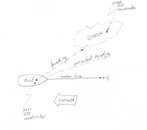
If I understood well, if you have the GPS coordinates of the wreck, you arrive to the spot with your boat, anchor it, the boat moves according to the current. Once the boat is stabilized (anchored and not drifting any more), check the current GPS coordinates, calculate the distance and direction to the GPS coordinates of the wreck, enter the water and with a compass follow the direction until the wreck. You will need to swim against the current. With the calculated distance, you can estimate the time swimming.
 

Attachments

  • wreck-heading.jpg
    wreck-heading.jpg
    15.4 KB · Views: 373
Get a cheap fish finder to locate the wreck once the GPS puts you on site, working without one is a waste of time if 10 meters makes that big a difference to you finding the wreck.
Usually the GPS coordinates given are not 100% perfect and their error plus your error equal a huge error.

Best thing to do is to find the site with the GPS, find the wreck with the fish finder, then CLEARLY BACK OFF the wreck and use the motor to hold station while lowering the anchor to the sea floor safely off the wreck and then back off until you have the correct scope ratio for the depth on your anchor rode and then lock it down and back up a bit more to firmly set it.
That way you can follow your own anchor line down to just off the wreck.

EDIT: Many taller wrecks have mooring buoys, but assuming this one doesn't be aware that if the wind does a 180 and your boat swings around to the other side you need enough clearance so your rode doesn't clip the wreck as that would be bad for both the wreck, your rode and your anchors ability to stay firmly set.
 
If I understood well, if you have the GPS coordinates of the wreck, you arrive to the spot with your boat, anchor it, the boat moves according to the current. Once the boat is stabilized (anchored and not drifting any more), check the current GPS coordinates, calculate the distance and direction to the GPS coordinates of the wreck, enter the water and with a compass follow the direction until the wreck. You will need to swim against the current. With the calculated distance, you can estimate the time swimming.

That is one way to do it but not the preferred method.
Use a reef anchor as described above - On your description/drawing the current runs right to left. Take the boat to the right of the structure/wreck and drop the "reef anchor" (with 2 to 3 times the amount of line - depth is 80 feet - use about 240 feet of line) with current pushing you over the wreck. The reef anchor will "slip" through the sand until it hits a hard surface - the wreck. Watch the GPS and make sure you are stable and not moving left. When you get to the bottom - check the anchor - you may need to tie it to the wreck - untie it before you leave the bottom unless you decide to do more than a 1 tank dive.
Does that help?

Edit - I use anchor chain to the reef anchor and I put a thimble in the rope to the chain.
 
Last edited:
A simple fish finder/echo sounder is far far more useful than a GPS. Use transmits, motor along a line of bearing and when you see the spike on the sounder, drop the shot line.
It's a better option than dragging an anchor across the sand stirring up the silt, decreasing visibility and risking damage over a fairly large area.

GPS simply might not be accurate enough to find a small target in poor visibility and strong currents. A fish finder confirms the target IS directly below the boat at the time you drop a shot.
 
Absent a marker buoy on the wreck, a fish finder or other sonar would be your best bet. Others have given you excellent advice for anchoring over the wreck assuming the GPS coordinates are accurate.

But GPS coordinates are often not accurate. Possible reasons are:
1. GPS Coordinates intentionally incorrect - Wreck divers, boat captains etc are often protective of a wreck site and if they publish a wreck site location they may put the location a mile or two off.
2. GPS Coordinates are older and taken at a time when for national security reasons there was a deliberate induced error in civilian GPS coordinates.
3. Since GPS does not work underwater the coordinates you have were either taken at the time of sinking and boats/ships don't drop straight down, or your coordinates were taken from a boat that had found the wreck and it may not have been directly over the wreck at the time it recorded the coordinates. So you can see why sonar, fish finder or magnetometer is a valuable tool.
4. This will surprise everyone (not!) but stuff underwater can and does move. This can include large ships. Storms, currents and shifting bottom structure can cause the wreck to creep over time.
5. If you have not found the wreck on previous dives, it is possible you are actually at the correct location and just don't recognize the wreck. Wrecks don't stay looking like a ship or boat forever underwater. If they are in shallow water they fall to pieces more quickly due to wave, surge and current action. If the wreck is older, it may be in pieces and present a fairly flat profile. Last wreck I visited was of a steel ship and the tallest piece was 3 feet tall. Steel plates all over the place. Don't forget that all sorts of marine live will cover the wreck too and that will add to its camouflage. You may be looking at a rock or other object underwater that is in fact part of the wreck covered in marine growth.


Hand held sonar the size of a D cell flashlight will help you on the surface and you can take it with you to assist in the locating the wreck underwater. http://aquaviews.net/scuba-gear/hand-held-sonar-devices-for-scuba-divers/# These devices are relatively inexpensive with some priced at $99.95

Wal-Mart sells Hand held sonar (fish finder) that is NOT submersible for $62.89 and boat mounted fish finders (sonar) start at $74.26 http://www.walmart.com/cp/Marine-Electronics/5188
 
I usually navigate to the coordinates with my bottom sonar running. Once I see the wreck, reef, outcropping with the bottom sonar I may drop a buoy. Or, I will just turn about 180 degrees and track back across it and repeat several times until I get a solid mark and idea of the lay and run of the feature. If needed I will switch to side scan mode to get a better idea of the nature of the feature, sometimes useful, sometimes not.

Once I have a good idea of the feature I tell my wife (mate) to ready the anchor and I motor up and put the bow on the mark or sonar indication and tell her to drop anchor on my command. Usually the anchor is sitting on the feature unless I intentionally place it off. Then I run out my scope and back down a bit to set anchor.

You really have to have a sonar, published marks, for whatever reason, are often not exact. I have two GPS and for one reason or other they do not always show exactly the same coordinates. But the difference is usually not very much and once I can see the feature on sonar it no longer matters because I am primarily positioning by the sonar, not the GPS.

N
 
https://www.shearwater.com/products/teric/

Back
Top Bottom