Accident & Incident Discussion - Northernone - aka Cameron Donaldson

Please register or login

Welcome to ScubaBoard, the world's largest scuba diving community. Registration is not required to read the forums, but we encourage you to join. Joining has its benefits and enables you to participate in the discussions.

Benefits of registering include

  • Ability to post and comment on topics and discussions.
  • A Free photo gallery to share your dive photos with the world.
  • You can make this box go away

Joining is quick and easy. Log in or Register now!

View attachment 511470
Quite a way north of Puerto de Abrigo


Along with the possibility of an unusually strong downcurrent indicative of the lack of bubbles on his decent reported by his mom and the reef damage that may have been more a last ditch effort to fight current too strong for the scooter and ended up at sea.
I'm probably a fool but I can't give up hoping...
 
They entered at the boat launch by Sedena.
So Sedena is pretty much in town, at the edge. The story the family posted in the fundraising (or maybe I'm thinking of the first news story) was Playa Rocas . Is Playa Rocas perhaps where his mother exited as opposed to where they entered?
 
I don't recall, Cameron's mother said what distance she thought she covered that day
 
I don't recall, Cameron's mother said what distance she thought she covered that day
She said two miles. That distance south of Playa las Rocas would be right around Guido's Italian Restaurant.
 
Guidos is downtown and is less than a mile south of entry point - the current travels to the north - 2 miles north of entry point is around Buccanos
 
Cantarel/Eagle Ray Wall is shown outside the Coral Princess and Las Brisas.
upload_2019-3-27_8-6-50.png


Here, you can see Sedena, Coral Princess, Las Brisas, and Buccanos. Puerto de Abrigo is also shown. Playa las Rocas is just past Las Brisas
upload_2019-3-27_8-12-40.png
 

Attachments

  • upload_2019-3-27_8-9-36.png
    upload_2019-3-27_8-9-36.png
    102.3 KB · Views: 54
Sorry @RayfromTX

Don't see the pin on map 2, actual surfacing

Thanks for posting, this helps a lot in visualizing the dive, something many of us have been trying to do
 
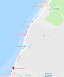
I’m still trying to understand the plan and what occurred on that dive. They scooter together on one scooter to the wall quickly. He goes over the wall and goes deep with the scooter and the mother is planning on waiting there for his return? Is that correct?

However on the last dive, he disappears or descends rapidly without a steam of bubbles rising, which in the most innocuous scenario, means there is a strong down current.

Presumably she waits there for a return or maybe has planned to follow along with the north bound current and can normally keep his rising bubble stream visible in excellent visibility ?????? Is that correct? Do they use a fixed or drifting rondevous point?

But on this dive he doesn’t return or meet up in a timely manner. Instead of aborting the dive and starting to look for the over due diver, she drifts north a mile or more ( I cannot see all the maps on my phone)? After she reaches shore, a surface search was not started with boats for several hours and aircraft were not brought in for about 24 hours? I don’t want to sound critical, and I know resources and communication are far different than the USA, I’m just trying to get a valid picture.

Is that the timeline and plan? It is so hard to try to discern what is known versus speculation on these threads because information has been provided peace meal and by different people and it is scattered over multiple threads.
 
https://www.shearwater.com/products/swift/

Back
Top Bottom