You are using an out of date browser. It may not display this or other websites correctly.
You should upgrade or use an alternative browser.
You should upgrade or use an alternative browser.
Watch out my brothers. This one is bad - typhoon Haiyan
- Thread starter Hank49
- Start date
Please register or login
Welcome to ScubaBoard, the world's largest scuba diving community. Registration is not required to read the forums, but we encourage you to join. Joining has its benefits and enables you to participate in the discussions.
Benefits of registering include
- Ability to post and comment on topics and discussions.
- A Free photo gallery to share your dive photos with the world.
- You can make this box go away
clgsamson
Koya Kap
Mantra
Contributor
Rappler.com has excellent coverage for those following along, including good live twitter coverage.
It looks pretty bad in Tacloban. But Malapascua must be right in the bullseye for this, I'm thinking? And it's so low lying there. Must be hitting right about now.
Any details on how Malapascua is faring would be good, and any details on where best to donate for relief efforts would be good too.
It looks pretty bad in Tacloban. But Malapascua must be right in the bullseye for this, I'm thinking? And it's so low lying there. Must be hitting right about now.
Any details on how Malapascua is faring would be good, and any details on where best to donate for relief efforts would be good too.
DevonDiver
N/A
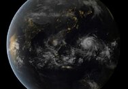
Hiayan (loc: 'Yolanda') now recorded as the most powerful storm in recorded history, having exceeded all scientific intensity scales...
Sustained winds of 190mph (305km/h) and staggering gusts of 230mph (370km/h), its "intensity has actually ticked slightly above the maximum to 8.1 on an 8.0 scale." Update: It broke 235mph.
To put this in perspective, the terminal speed of a skydiver is just 200km/h (125mph)...
Super typhoon Haiyan just broke all scientific intensity scales

DevonDiver
N/A
Devondiver and other Philippines scubaboard members where are you hunkering down?
DevonDiver
N/A
Devondiver and other Philippines scubaboard members where are you hunkering down?
I'm here in Subic. We're on a storm warning (diving cancelled), but the conditions aren't bad (yet). We're expecting our turn tomorrow morning as the storm moves W-N-W and passes below us.
My thoughts are with those in the central regions, especially Matt Reed and his crew at Evolution in Malapascua, which was right in the track.
---------- Post added November 8th, 2013 at 02:55 PM ----------
Heavy rains reached Subic Bay in the last 20 minutes..
Tippytoes12
Contributor
I have just seen on Ocean Vidas facebook page that the resort has been boarded up and the guests taken to Cebu. Let's hope this passes soon x
Hank49
Contributor
I've been staying in touch with a friend on Boracay and another in Iloilo. The eye seems to have passed Boracay. He's okay. Lot of broken trees but he says everyone seems to be ok.
It's moving fast so should be over in a couple hours there.
It's moving fast so should be over in a couple hours there.
DevonDiver
N/A
The effects are starting to present here in Subic. Looks like Manila/Subic/Luzon might take a hit, despite the storm passing below us:
NASA: 'Yolanda's' strong side could affect Metro Manila | ABS-CBN News

---------- Post added November 8th, 2013 at 07:31 PM ----------
BBC News: In pictures - Typhoon Haiyan
BBC News: Monster storm roars into Philippines
Sky News: Super Typhoon Haiyan Hits The Philippines
---------- Post added November 8th, 2013 at 07:40 PM ----------
Dr. Jeff Masters' WunderBlog : Super Typhoon Haiyan: Strongest Landfalling Tropical Cyclone on Record | Weather Underground
Extreme damage likely in the Philippines
Wind damage in Guiuan (population 47,000) must have been catastrophic, perhaps the greatest wind damage any city on Earth has endured from a tropical cyclone in the past century. A massive storm surge must have also caused great destruction along a 20-mile swath to the north of where the eye hit, where Project NOAH was predicting a 17’ (5.3 meter) storm tide.
Wind damage will also be extreme in Tacloban, population 221,000, the capital of the province of Leyte. Much of Tacloban is at elevations less than ten feet, and the most recent storm surge forecast made by the Philippines' Project NOAH calls for a storm tide (the combined height of the surge plus the tide) of 12’ (3.6 meters) in Tacloban. The northern (strong) part of Haiyan’s eyewall is now battering the southern part of the city. Haiyan’s winds, rains, and storm surge will cause widespread devastation throughout the Central Philippines during the day, though the storm’s fast forward speed of 25 mph will cut down on the total rainfall amounts, compared to typical typhoons that affect the Philippines.
Hopefully, this will substantially recede the death toll due to flash flooding, which is usually the biggest killer in Philippine typhoons. Once Haiyan exits into the South China Sea, it will steadily decay, due to colder waters and higher wind shear. However, it will still be a formidable Category 1 or 2 typhoon when it hits Vietnam and Laos, and I expect that the 12+ inches of rain that the storm will dump on those nations will make it a top-five most expensive natural disaster in their history. Early on Thursday, Haiyan hit the island of Kayangel, 24 kilometres north of Palau's capital, Koror. Damage was heavy, with many homes damaged or destroyed, but there were no injuries among the island’s 69 inhabitants.
NASA: 'Yolanda's' strong side could affect Metro Manila | ABS-CBN News

Super typhoon Yolanda breaks scientific intensity scale
MANILA - Metro Manila will be directly affected by the passage of super typhoon Yolanda (international name Haiyan) in the Philippines, the US National Aeronautics and Space Administration (NASA) warned Thursday night.
Citing the Hawaii-based Joint Typhoon Warning Center (JTWC), NASA said in a report on the typhoon that the metropolis won't be spared by the typhoon, even if it is not on its direct path.
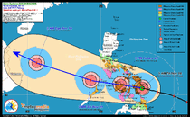
"According to [JTWC] forecast track, Manila is now expected to be impacted by the northeastern quadrant, the strongest side of the storm," NASA said.
Philippine state weather bureau PAGASA raised storm signal number 2 over Metro Manila Friday morning.
Twenty areas, meanwhile, were placed under storm signal number 4, the highest level in PAGASA's storm warning system.
NASA said it is providing visible, infrared and microwave satellite data to forecasters worldwide on the super typhoon.
The space agency quoted Brian McNoldy, a senior research associate at the University of Miami's Rosenstiel School of Marine and Atmospheric Science in Miami, Fla. as saying that Yolanda attained "perfection" November 7 by reaching 8.0 on the Dvorak scale, the highest possible value.
Other meteorologists, meanwhile, said the super typhoon continued to intensify and broke the Dvorak scale used to gauge a cyclone's intensity.
---------- Post added November 8th, 2013 at 07:31 PM ----------
BBC News: In pictures - Typhoon Haiyan
BBC News: Monster storm roars into Philippines
Sky News: Super Typhoon Haiyan Hits The Philippines
---------- Post added November 8th, 2013 at 07:40 PM ----------
Dr. Jeff Masters' WunderBlog : Super Typhoon Haiyan: Strongest Landfalling Tropical Cyclone on Record | Weather Underground
Extreme damage likely in the Philippines
Wind damage in Guiuan (population 47,000) must have been catastrophic, perhaps the greatest wind damage any city on Earth has endured from a tropical cyclone in the past century. A massive storm surge must have also caused great destruction along a 20-mile swath to the north of where the eye hit, where Project NOAH was predicting a 17’ (5.3 meter) storm tide.
Wind damage will also be extreme in Tacloban, population 221,000, the capital of the province of Leyte. Much of Tacloban is at elevations less than ten feet, and the most recent storm surge forecast made by the Philippines' Project NOAH calls for a storm tide (the combined height of the surge plus the tide) of 12’ (3.6 meters) in Tacloban. The northern (strong) part of Haiyan’s eyewall is now battering the southern part of the city. Haiyan’s winds, rains, and storm surge will cause widespread devastation throughout the Central Philippines during the day, though the storm’s fast forward speed of 25 mph will cut down on the total rainfall amounts, compared to typical typhoons that affect the Philippines.
Hopefully, this will substantially recede the death toll due to flash flooding, which is usually the biggest killer in Philippine typhoons. Once Haiyan exits into the South China Sea, it will steadily decay, due to colder waters and higher wind shear. However, it will still be a formidable Category 1 or 2 typhoon when it hits Vietnam and Laos, and I expect that the 12+ inches of rain that the storm will dump on those nations will make it a top-five most expensive natural disaster in their history. Early on Thursday, Haiyan hit the island of Kayangel, 24 kilometres north of Palau's capital, Koror. Damage was heavy, with many homes damaged or destroyed, but there were no injuries among the island’s 69 inhabitants.


