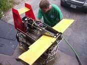
As my screen name says, I work as an Oceanographer. The project I work on involves using a $200,000 towed sensor package with all sorts of instruments for measuring things like salinity, temperature, dissolved oxygen, light, zooplankton, chlorophyll, nitrate and primary productivity. This instrument can fly up and down as we tow it allowing it to profile the whole water column. We had been using an older system that did most of the same things between 1998 and 2008. In 2009 we'd upgraded to a shiny new model. All the years we'd been doing it, we'd always brought the sensor home at the end of the day.
Well, there is a saying in Oceanography that anytime you put a sensor in the water, you might not get it back. Unfortunately, July 16th, we proved the correctness of that statement with the shiny new instrument. We were doing a survey of Narragansett Bay steaming along at 9 kts towing the sensor. Everything was working great. We were right off the south end of Prudence Island in the shipping channel with a little over 90 ft of water below us. As I was watching the computer displaying the sensor's flight pattern I saw it do a weird little wobble as it was surfacing and thought "What the heck is that?" About 3 seconds later, before I really had a chance to figure out what was going on, and just as the sensor hit about 25 ft below the surface I heard a loud BANG! I ran out on deck and saw to my horror the snapped end of our tow wire hanging from the winch, it had snapped right at the towing block. Our shiny new $200,000 sensor had gone to the bottom! Worse still, our old emergency locator beacon intended to allow us to recover it in such an emergency had died months earlier and we had yet to get money in the budget to replace it. All I had to go on was the GPS numbers for the boat when the cable broke. Presumably it had fouled on some submerged line, probably lobster gear, but we'll never know for sure what it was.
Having the GPS numbers might make recovering it seem easy but it was actually a rather difficult problem. The numbers we had were those of the boat, not the sensor so we had to guess the numbers for the sensor. Since the towfish was fouled and 70 ft off the bottom when it broke free, its trajectory and final resting place were a bit hard to estimate. it was in a heavily trafficked shipping channel in an area littered with lobster gear. It was 90-100ft deep in the area. It was also a high current area only diveable at slack water. Worse, it was a mud bottom and far enough up the bay that the typical visibility on the bottom was 0-3 ft with no ambient light at all. And worse still, we had no money in our project budget so we couldn't pay for an expensive recovery!
I went back to the lab, made some calls and emails and put together a dive team consiting of myself, plus Jerry from NOAA, Matt from URI and Jason from URI. I also talked the MERL Lab at URI into providing us with a 21 ft boat to dive from. The next day our team of volunteer divers set out and dove the numbers.
We struck out. We had to wait for a large tanker to pass delaying our dive. When we finally got to the bottom the visibility was terrible and any careless movements resulted in instant silt outs. Worse, there was so much lobster gear on the bottom that a circle search resulted in repeatedly fouling the search reel on lobster pots, slowing our progress.
The following week, my friend John L offered to take me out to try and grapple and dive for it in his free time. We again struck out and found nothing but lobster pots.
I realized we needed a better fix to find it in those conditions (at least without having to do an inordinate number of dives in a rather hazardous spot). The NOAA navigational response team and the US Navy both agreed to help us by sidescanning the area. The problem was neither would be able to do anything until August. So instead, I tracked down my good friend John (Scubaboard's Sean222) and convinced him to help me by bringing out his personal sidescan that he uses for wreck hunting.
We found a very promising target so I put another dive together with the same team, but a different boat (provided by the URI Coastal Ecology group with Steve G. as the skipper). Again, two dives, nothing but lobster pots!
Last week, the Navy got out there and could not report anything they thought was clearly our tow-fish. They just said all the lobster gear made it hard to figure out which target might be our sensor. Finally Monday I went out with NOAA Nav response team in their 30 ft boat. We sidescanned the area very thoroughly and we could clearly discern the lobster gear from other harder objects with their gear. We found 4 targets in the right area that were too hard a return to be a lobster pot but were about the right size. One target was within 17 m of where I guessed it would have landed with the GPS fix at the moment of the cable break. It was also close enough to the target John located with his side-scan that I think it was probably the same one, but this time with a more accurate position estimate.
This afternoon the same dive team made a third try. Jason begged me to let he and Matt do the first dive. They were being nice enough to help for free and as badly as I wanted to find it myself, I figured I owed him for helping me out so I let him go first. If the first target didn't pan out we'd move on the the next one for dive 2.
If they found it, the plan was to first Mark it with a buoy, then time permitting clear any obstructions and surface. Dive team 2 (Jerry and I) would then go down with a 200lb lift bag and float it.
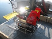
We dropped a shotline on the numbers and team 1 descended at slack tide. As soon as they hit the bottom, just 5 ft from the shotline they found the instrument's tow wire half buried in the mud. They followed it 15 ft and discovered the sensor sitting upright on the bottom in pretty good condition though one wing clearly had taken damage when it fouled whatever broke the cable.
On the boat, I was eagerly waiting and suspected something was up because when the dive team hit the bottom, instead of seeing the bubbles circling in a search pattern. I saw them promptly go 15 ft to the south then stop for a couple minutes. As I watched the location of the bubbles I suddenly saw the big orange SMB break the surface to mark the location of the sensor. Everyone on the boat began to cheer.
Once Jason and Matt were out of the water Jerry and I splashed in eagerly. We hooked up the big lift bag. I used my pony regulator to fill it. It filled and filled and after what seemed like an eternity the instrument slowly began to rise. We got it up and to the side of the boat and tied three lines to it. It wasn't getting away from me again!!!! We then hauled the 180lb sensor aboard! At last we could all relax!
It felt great to get it back! Getting it working again will be quite a project but boy do I feel good tonight!
Big thanks to Jason Krumholz and Matt Horn of URI along with Jerry Prezioso of NOAA who made up the dive team along with myself. Thanks also to Leslie Smith of URI (boat driver), John Stanford (sidescan donator and operator), Lt. Matt Jaskowski of NOAA's NR-5 team (side-scan), Cmdr. Matt Wingate of NOAA (facilitated the sidescan and helped us deal with ship traffic as a liason with the harbor pilots), the USN MARV team (sidescan), Steve Grainger (Boat Driver), Dr. Candace Oviatt of URI (Boat Provider), John Langella (boat provider) and Mark Gustafson (URI dive safety officer for facilitating the URI diver's participation).
Well, there is a saying in Oceanography that anytime you put a sensor in the water, you might not get it back. Unfortunately, July 16th, we proved the correctness of that statement with the shiny new instrument. We were doing a survey of Narragansett Bay steaming along at 9 kts towing the sensor. Everything was working great. We were right off the south end of Prudence Island in the shipping channel with a little over 90 ft of water below us. As I was watching the computer displaying the sensor's flight pattern I saw it do a weird little wobble as it was surfacing and thought "What the heck is that?" About 3 seconds later, before I really had a chance to figure out what was going on, and just as the sensor hit about 25 ft below the surface I heard a loud BANG! I ran out on deck and saw to my horror the snapped end of our tow wire hanging from the winch, it had snapped right at the towing block. Our shiny new $200,000 sensor had gone to the bottom! Worse still, our old emergency locator beacon intended to allow us to recover it in such an emergency had died months earlier and we had yet to get money in the budget to replace it. All I had to go on was the GPS numbers for the boat when the cable broke. Presumably it had fouled on some submerged line, probably lobster gear, but we'll never know for sure what it was.
Having the GPS numbers might make recovering it seem easy but it was actually a rather difficult problem. The numbers we had were those of the boat, not the sensor so we had to guess the numbers for the sensor. Since the towfish was fouled and 70 ft off the bottom when it broke free, its trajectory and final resting place were a bit hard to estimate. it was in a heavily trafficked shipping channel in an area littered with lobster gear. It was 90-100ft deep in the area. It was also a high current area only diveable at slack water. Worse, it was a mud bottom and far enough up the bay that the typical visibility on the bottom was 0-3 ft with no ambient light at all. And worse still, we had no money in our project budget so we couldn't pay for an expensive recovery!
I went back to the lab, made some calls and emails and put together a dive team consiting of myself, plus Jerry from NOAA, Matt from URI and Jason from URI. I also talked the MERL Lab at URI into providing us with a 21 ft boat to dive from. The next day our team of volunteer divers set out and dove the numbers.
We struck out. We had to wait for a large tanker to pass delaying our dive. When we finally got to the bottom the visibility was terrible and any careless movements resulted in instant silt outs. Worse, there was so much lobster gear on the bottom that a circle search resulted in repeatedly fouling the search reel on lobster pots, slowing our progress.
The following week, my friend John L offered to take me out to try and grapple and dive for it in his free time. We again struck out and found nothing but lobster pots.
I realized we needed a better fix to find it in those conditions (at least without having to do an inordinate number of dives in a rather hazardous spot). The NOAA navigational response team and the US Navy both agreed to help us by sidescanning the area. The problem was neither would be able to do anything until August. So instead, I tracked down my good friend John (Scubaboard's Sean222) and convinced him to help me by bringing out his personal sidescan that he uses for wreck hunting.
We found a very promising target so I put another dive together with the same team, but a different boat (provided by the URI Coastal Ecology group with Steve G. as the skipper). Again, two dives, nothing but lobster pots!
Last week, the Navy got out there and could not report anything they thought was clearly our tow-fish. They just said all the lobster gear made it hard to figure out which target might be our sensor. Finally Monday I went out with NOAA Nav response team in their 30 ft boat. We sidescanned the area very thoroughly and we could clearly discern the lobster gear from other harder objects with their gear. We found 4 targets in the right area that were too hard a return to be a lobster pot but were about the right size. One target was within 17 m of where I guessed it would have landed with the GPS fix at the moment of the cable break. It was also close enough to the target John located with his side-scan that I think it was probably the same one, but this time with a more accurate position estimate.
This afternoon the same dive team made a third try. Jason begged me to let he and Matt do the first dive. They were being nice enough to help for free and as badly as I wanted to find it myself, I figured I owed him for helping me out so I let him go first. If the first target didn't pan out we'd move on the the next one for dive 2.
If they found it, the plan was to first Mark it with a buoy, then time permitting clear any obstructions and surface. Dive team 2 (Jerry and I) would then go down with a 200lb lift bag and float it.
We dropped a shotline on the numbers and team 1 descended at slack tide. As soon as they hit the bottom, just 5 ft from the shotline they found the instrument's tow wire half buried in the mud. They followed it 15 ft and discovered the sensor sitting upright on the bottom in pretty good condition though one wing clearly had taken damage when it fouled whatever broke the cable.
On the boat, I was eagerly waiting and suspected something was up because when the dive team hit the bottom, instead of seeing the bubbles circling in a search pattern. I saw them promptly go 15 ft to the south then stop for a couple minutes. As I watched the location of the bubbles I suddenly saw the big orange SMB break the surface to mark the location of the sensor. Everyone on the boat began to cheer.
Once Jason and Matt were out of the water Jerry and I splashed in eagerly. We hooked up the big lift bag. I used my pony regulator to fill it. It filled and filled and after what seemed like an eternity the instrument slowly began to rise. We got it up and to the side of the boat and tied three lines to it. It wasn't getting away from me again!!!! We then hauled the 180lb sensor aboard! At last we could all relax!
It felt great to get it back! Getting it working again will be quite a project but boy do I feel good tonight!
Big thanks to Jason Krumholz and Matt Horn of URI along with Jerry Prezioso of NOAA who made up the dive team along with myself. Thanks also to Leslie Smith of URI (boat driver), John Stanford (sidescan donator and operator), Lt. Matt Jaskowski of NOAA's NR-5 team (side-scan), Cmdr. Matt Wingate of NOAA (facilitated the sidescan and helped us deal with ship traffic as a liason with the harbor pilots), the USN MARV team (sidescan), Steve Grainger (Boat Driver), Dr. Candace Oviatt of URI (Boat Provider), John Langella (boat provider) and Mark Gustafson (URI dive safety officer for facilitating the URI diver's participation).
Last edited:
")