Went to the bridge for diving to day. Arrived at 0835 for a 1003 high tide. It was not crowded when I arrived, but by the time I finished my dive the parking lot was somewhat more full, surprising given that it was a Monday and it was raining. Entered the water on the west side at 0900. Visibility was 40ft but with hazy glare to it, sea temp was 78f. Did a REEF fish count 69 species in 60 minutes. Standout for the day was Bandtail Sea Robin, with beautifully dark pectoral fins it kept furling and unfurling. Also of interest was a decorator/neck crab. Last week I reported one that had taken on a brown algae and leaf motif, as opposed to orange sponge motif I observe most often. The one I observed today has adopted a green feather algae motif. Respectively, Balloon Fish, Bandtail Sea Robin, Banner Gobies, Hitchhiker Anemone, Bandtail Sea Robin Video, and Neck/Decorator with green feather algae.


You are using an out of date browser. It may not display this or other websites correctly.
You should upgrade or use an alternative browser.
You should upgrade or use an alternative browser.
Blue Heron Bridge Trolls III
- Thread starter BHB ScubaTroll
- Start date
Please register or login
Welcome to ScubaBoard, the world's largest scuba diving community. Registration is not required to read the forums, but we encourage you to join. Joining has its benefits and enables you to participate in the discussions.
Benefits of registering include
- Ability to post and comment on topics and discussions.
- A Free photo gallery to share your dive photos with the world.
- You can make this box go away
oldflounder
Contributor
- Messages
- 543
- Reaction score
- 76
- # of dives
- 200 - 499
Would love to see that map old flounder ...
On a sad note, this seems to be right out by the bridge
Good Samaritan dies trying to save kids off capsized boat
Out by the inlet near peanut island in Riviera Beach ... : (
Attachments
oldflounder
Contributor
- Messages
- 543
- Reaction score
- 76
- # of dives
- 200 - 499
A very basic rendition of the pillarsWould love to see that map old flounder ...
On a sad note, this seems to be right out by the bridge
Good Samaritan dies trying to save kids off capsized boat
Out by the inlet near peanut island in Riviera Beach ... : (
Attachments
oldflounder
Contributor
- Messages
- 543
- Reaction score
- 76
- # of dives
- 200 - 499
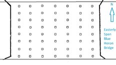
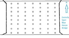
To be added to later. Just went snorkeling today to check it out.A very basic rendition of the pillars
Attachments
Sheesh! Dived the east span many times, never thought there were that many pillars!!!
oldflounder
Contributor
- Messages
- 543
- Reaction score
- 76
- # of dives
- 200 - 499
Sheesh! Dived the east span many times, never thought there were that many pillars
oldflounder
Contributor
- Messages
- 543
- Reaction score
- 76
- # of dives
- 200 - 499
7 rows of 8 or 8 rows of 7...all depends on how you are counting.
oldflounder
Contributor
- Messages
- 543
- Reaction score
- 76
- # of dives
- 200 - 499
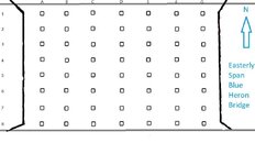
Updated sketch BHB east span pillars.

oldflounder
Contributor
- Messages
- 543
- Reaction score
- 76
- # of dives
- 200 - 499
If anyone wants to pm me their favorite landmarks or bottom features I will add them to this sketchUpdated sketch BHB east span pillars.View attachment 718327
Ana
.
This bridge is structure # 930545, maintained by FDOT.Updated sketch BHB east span pillars.View attachment 718327
You probably can get information about the basic geometry of the structure contacting them, some details may be withheld in order to avoid crazy people to damage the structure, but I'm sure length and width is available, anyone can take a measuring device and find out so it would be silly to make that secret.
Your labels are pretty close to how they code them nation wide. Spans are numbered west to east, standing on the end bent #1 by the west approach, then pile bent #2, 3, 4... . up to end bent #9. Then each pile is labeled from left to right, just like your sketch. That way if you refer to pile 8-1 everyone would know is the one at the top right, or pile 1-8 is at the bottom left, would come handy if anyone tells you there's a whatever by a particular pile.
Similar threads
- Replies
- 10
- Views
- 1,234
- Replies
- 9
- Views
- 1,188
- Replies
- 0
- Views
- 609


