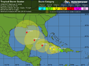
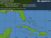
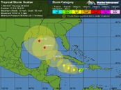
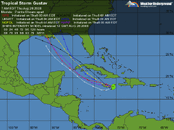
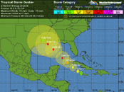
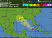
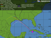
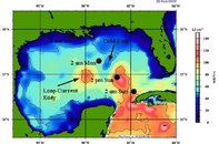
Gustav Looks at Northern Caribbean - Keep the shutters up

Please register or login

Welcome to ScubaBoard, the world's largest scuba diving community. Registration is not required to read the forums, but we encourage you to join. Joining has its benefits and enables you to participate in the discussions.

Benefits of registering include

  • Ability to post and comment on topics and discussions.
  • A Free photo gallery to share your dive photos with the world.
  • You can make this box go away

Joining is quick and easy. Log in or Register now!

The hills of Haiti certainly did knock him back a notch, but he'll back. Looks like Cozumel diving may be out Sunday, then who knows where next week? Florida Panhandle, New Orleans, Houston...??
 

Attachments

  • Tropical Storm Gustav.gif
    Tropical Storm Gustav.gif
    37.6 KB · Views: 72
  • Tropical Storm Gustav 2.gif
    Tropical Storm Gustav 2.gif
    35.7 KB · Views: 64
the models are starting to shift it north earlier now and take it over cuba. that might tear it up quite a bit and miss the warm eddy.
 
If Cuba has big hills where it crosses, it'll take some spunk out. Plane is going out today to look...
 
This morning's forecast is nasty, slowing the storm's arrival in Louisiana by nearly a day, while keeping the eye over water all the way to the Gulf coast... and putting Grand Cayman right in the northeastern eye-wall as it passes there.
Not good...
Rick
 
This morning's forecast is nasty, slowing the storm's arrival in Louisiana by nearly a day, while keeping the eye over water all the way to the Gulf coast... and putting Grand Cayman right in the northeastern eye-wall as it passes there.
Not good...
Rick
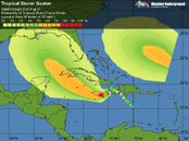
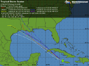
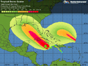
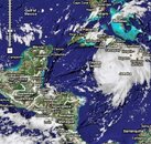
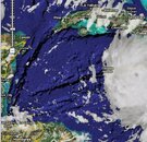
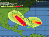
Veering a little closer to Cozumel, Cancun and Holbox it seems....
 

Attachments

  • H Gus.gif
    H Gus.gif
    36.6 KB · Views: 67
  • H Gus 2.gif
    H Gus 2.gif
    35.3 KB · Views: 61
  • H Gus 3.gif
    H Gus 3.gif
    33.9 KB · Views: 64
Path shifting a little away from the Yucatan, just now arriving in the Caymans...
 

Attachments

  • Gus.gif
    Gus.gif
    47.2 KB · Views: 76
  • Gus 2.gif
    Gus 2.gif
    43.7 KB · Views: 63
  • Gus 3.gif
    Gus 3.gif
    49.3 KB · Views: 50
  • Screen02_edited.JPG
    Screen02_edited.JPG
    94.7 KB · Views: 65
  • Screen03_edited.JPG
    Screen03_edited.JPG
    75.2 KB · Views: 56
back up to hurricane strength and getting bigger and sucking up energy from warm water.

check out this comment:

Wunder Blog : Weather Underground

"It's time to leave New Orleans
Today is the 3rd anniversary of Hurricane Katrina's catastrophic hit on the Louisiana/Mississippi/Alabama coast. Unfortunately, I think that people living in New Orleans should mark the anniversary of Katrina by getting the heck out of the city. You live at the bottom of a bowl, ten or so feet below sea level. This is not natural. Nature wants to fill up this bowl with huge quantities of Gulf of Mexico sea water. There is a storm capable of doing that bearing down on you. If you live in New Orleans, I suggest you take a little Labor Day holiday--sooner, rather than later, to beat the rush--and get out of town. Gustav is going to come close to you, and there's no sense messing with a major hurricane capable of pushing a Category 3 storm surge to your doorstep."

Although he later gives only a 10% chance of hurricane force winds hitting NOLA.
 
A major jump to Cat-4 now going for Cat-5. Tough one for western Cuba. Projections for Louisiana into Texas suggest seeking high ground ASAP whether the windows are covered are not. If he does hit that cold eddy, that could weaken him a little, but still a major threat for the lowlands. A couple of models project him turning left and heading down the coast. :11: Talk about worst case scenarios - just nearly!
 

Attachments

  • Gus.gif
    Gus.gif
    34 KB · Views: 83
  • Gus2.gif
    Gus2.gif
    33.4 KB · Views: 52
  • Gus3.gif
    Gus3.gif
    36.3 KB · Views: 67
  • Hurricanes.JPG
    Hurricanes.JPG
    115.1 KB · Views: 58
  • Eddy.jpg
    Eddy.jpg
    90.1 KB · Views: 49

Back
Top Bottom