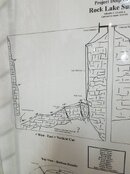
I don't know about that survey, but our group has done quite a bit of exploration We have made a number of maps of what we have found, and we have laid lines to key points.
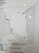
It is hard to say what the depth is at the south end. Unlike the rest of the lake it slopes toward the center of the lake, and it is hard to identify the bottom point. There is a fairly clear flattening out at about 200 feet, after which it slowly slopes to the middle of the lake, which is about 265.
The deepest point any of us have found at the north end is 280 feet, and we achieved that by thrusting a computer-laden wrist deep into the silt.
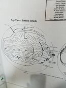
The east line ties off to a rock at about 185 feet. That is the top of the débris cone. If you are pretty much anywhere in the lake and want to find the east line, find a hill and climb to the top.
There are several vents bringing water into the lake at the bottom of the east line. We have seen some old surveys of unknown origin calling them "warm water vents," but a hydrologist in our group says they are actually just bringing in water at normal ground water temperature into the colder lake temperature. There are other vents scattered around the lake. They are easy to find after a bad fall algae bloom causes a black layer to cover the bottom. The vents send the light silt up through them.
We have laid several lines across the lake connecting the east line to the north line and the west line.
There are two north lines. The old one slopes at about a 30° angle to the middle of the lake, ending up just slightly north of an imaginary line between the east and west lines. We dropped a new north line at the same starting point, and this one is vertical.
We added extensions to the north and west lines so they could be found from the surface.
Our exploration efforts have fallen off, and we haven't done anything serious in that regard for a few years.