Storm watch until 9 October

Please register or login

Welcome to ScubaBoard, the world's largest scuba diving community. Registration is not required to read the forums, but we encourage you to join. Joining has its benefits and enables you to participate in the discussions.

Benefits of registering include

  • Ability to post and comment on topics and discussions.
  • A Free photo gallery to share your dive photos with the world.
  • You can make this box go away

Joining is quick and easy. Log in or Register now!

Doc

Was RoatanMan
Rest in Peace
Scuba Instructor
Messages
10,954
Reaction score
4,130
Location
Chicago & O'Hare heading thru TSA 5x per year
# of dives
None - Not Certified
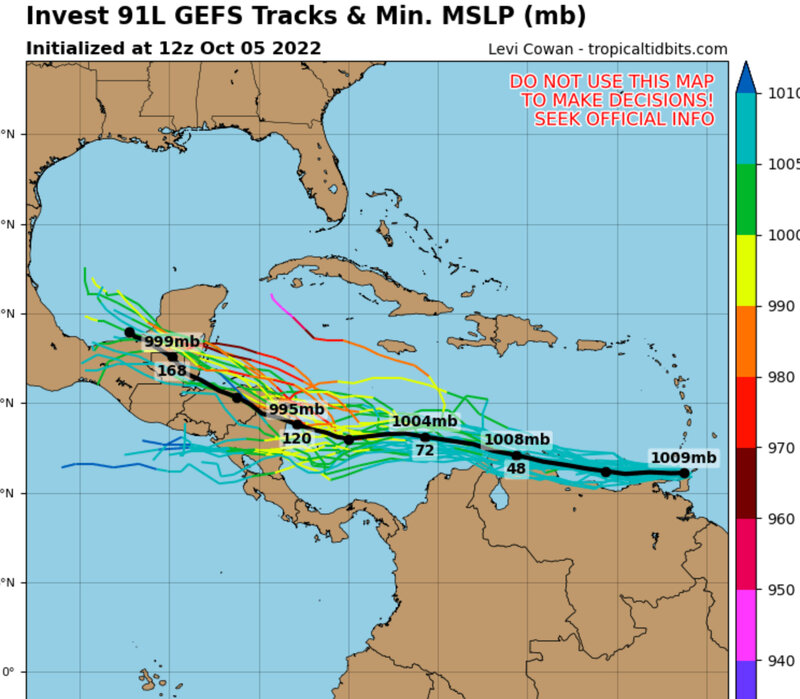
I’d still go, but something to watch with weekend air connections…

4003C99C-A3A6-4531-AF0F-6D0F6CA58A80.jpeg


Accuweather video: Click on this, lot’s of forecasting smarts…

D87C752C-36D2-430A-B8E5-B6ED8B04856A.jpeg
 
10/06 Thursday… it’s a rain event for the Bay Islands

a ‘Norther’ is now upon the Bay islands. It is raining and blowing pretty good…from the North (hence the name)

There will e a calm before the landfall of Invest 91L, maybe on Friday, and then the Bay Islands anticipates more and heavier rains. The models show, what winds there might be, will hit 60 miles to the South on the mainland…but not before hitting Corn Islands off the Eastern coast.

Some very limited access by webcam, but here’s what i scrounged. Dead flat calm on the South side, more than a bit rough on the West/North.

Diving continues
(West end view)
34BD4E2B-5F07-4716-A4C2-196404F89F85.jpeg

Looking West
D990A88D-327E-4088-9DB3-3D5A9975B99C.jpeg

Looking west from CCV:
CB112B87-F8AF-42E4-8CC7-C70642AC6085.jpeg

The broad picture, note Invest 91L swirling over ABC blowing and raining…
0723526C-120B-4862-AB24-628737FDDA1F.jpeg


How the weather service shows real-time righty now over Bay Islands….

737F5E3C-623A-462B-B980-79D4FCF6DC1C.jpeg


Good update link: Potential Tropical Cyclone 13L LIVE Tracker and Forecast | Zoom Earth

note below how predicted track has nudged Southward….


421BB204-1F29-4090-AEEE-7079E499466C.jpeg


This is a hIstorical chart of rainfall. I have posted similar previously. That we are in the heaviest rainfall period has been disputed by many tourism cheerleaders here and on TA. It is, what it is, quite obviously…

FA44B893-0B1F-4D57-97A3-D7AC6869900F.jpeg


Corrupted file screen shot from CoCoView (south), dead calm
02BABF7D-7642-476C-8F91-235F74EE18D0.jpeg


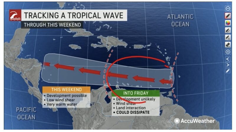
This is CCV’s ‘weather forecasting doggo’…
63E49510-DA97-423F-A158-A3FF55DC3174.jpeg
 
Forecast tracks look good for Bay Islands. Just some rain.

This displays the potential storm track. As days progress, the prediction becomes less certain, that’s why then ‘cone’ gets larger. It does NOT denote the expected width or footprint of any storm, just showing the widest area of error in track prediction…


83F6B654-49DB-4DFC-A9D6-2FC265E894ED.jpeg

Note the wind directions, pushing system to South….
06B64396-2FD2-49F1-B341-FDECB6318A6E.jpeg

My best guess….

A70A49D3-43BB-4837-AD60-2241400B0C7A.jpeg
 
This, from the Sheldon Cooper types:

The track forecast is straightforward. The disturbance is being
driven quickly westward with a motion of 270/15 kt by a strong low-
to mid-level ridge stretching across the western Atlantic and Gulf
of Mexico. This feature should maintain the system on a westward
heading for the next 3 days across the southwestern Caribbean Sea,
with some slowing of the forward motion as it moves away from the
main high center over the western Atlantic. A slight turn toward
the west-northwest across Central America is forecast by day 4 once
the system, or its remnants, reaches the western periphery of the
ridge. The track models remain tightly clustered, and the new NHC
forecast is near the previous prediction and the TVCN/HCCA
consensus aids.
 
Friday morning 08:30 local
Diving ops moving and seas are flat
B82A7B1F-D4E9-45F1-B523-A193BD8F7FC8.jpeg

00370409-A27D-49FE-B90B-6E9F1184244E.jpeg
C295A800-D755-4506-9D86-F04F2EA7FEC3.jpeg
9395185D-F2E2-4AE3-9C96-86361B84B8B6.jpeg
BD53BCE7-CDC1-4119-A671-2B844F5A0554.jpeg
04D5E94B-3A11-4574-AB26-27B27986B4C5.jpeg
714CDD57-8322-4F1E-9169-FD2AD1B3E80C.jpeg
 
oh hell. that's going to pass directly over Isla Providencia. they just can't catch a break, it seems.
 
  • Like
Reactions: Doc
Slowing down, building some limited strength, track being better defined- sagging Southward. Corn island, San Andres, Providencia… all SCUBA destinations
F90E6FEF-0136-4934-B12F-DACA10D43CF0.png
off the East of the Cape of Honduras, it’s still going to get it.
A5870245-116C-4475-A83E-64DF49D3E55F.png
773CC51F-80F8-45B4-A243-8222B00B0EAE.jpeg


F90E6FEF-0136-4934-B12F-DACA10D43CF0.png
A5870245-116C-4475-A83E-64DF49D3E55F.png
773CC51F-80F8-45B4-A243-8222B00B0EAE.jpeg
 
We’re done here, from the Bay Islands perspective, and for the on and off rains that linger. No info from San Andres and Corn.

Note how original track predictions were pretty close but a reminder to not place all bets too early.

AE6A4BE5-425D-4C3B-820F-07CFD25FFCDB.jpeg
6C5A31C3-5D98-41E4-8998-470C0FDB8181.jpeg
90E5AAC0-AC07-4D3F-819D-7B710CAC5E32.png
 
Our flight out of Roatan last night was delayed a few hours as the aircraft couldn’t land in the fog/rain/wind - diverted to Belize to refill fuel and came back for us later. We overnighted in Dallas and are on the way home now. Was hoping to dodge Julia. Glad to have gotten out ok.
 
Here in Utila, all of this activity between Ian and now Julia has just made it look like an early rainy season, but that is all we got from them - rain. Glad for it! Now, on to rainy season! :D
 
https://www.shearwater.com/products/teric/

Back
Top Bottom