SS Copenhagen Please Read

Please register or login

Welcome to ScubaBoard, the world's largest scuba diving community. Registration is not required to read the forums, but we encourage you to join. Joining has its benefits and enables you to participate in the discussions.

Benefits of registering include

  • Ability to post and comment on topics and discussions.
  • A Free photo gallery to share your dive photos with the world.
  • You can make this box go away

Joining is quick and easy. Log in or Register now!

ScubaBrett22

Lionfish Slayer
Messages
444
Reaction score
0
Location
Boca Raton / Parkland FL
# of dives
100 - 199
okay i went to the SS Copenhagen and i am still beating my self up for this so i need some help... I went down off the back of my friends boat and we went to buoy #4 we were tied of to Buoy #3 and we got the ledge went to far west is and never found the wreck i all most cried ... no really because i *********ed up big time i promised my friend a wreck and i couldn't find it the map was to cruddy. does anyone know the proper way to get to it next time we are going down the buoy and heading West i knew the wreck was mocking me from behind lol xD any other tips on how to find this wreck.

Also i made a new Picture from some old picture with a better compos Rose Please Note I took the original picture from this site
index.htm


CopenhagenSitePlan.jpg
 
Brett,
If you did in fact attach the boat to Buoy #3 and you did go east. I cannot understand how you could not have gotten into the debris field.
I hope you understand that the Copenhagen is pretty flat. Did you see the plaque and the anchor at the south end?
Send me a private message if you like, and we can talk. I may be able to help.
I am in Coconut Creek and have hit this thing about 30 times, usually from the beach.
Regards,
Chug
 
It's right at the ledge between the third and fourth ball, directly east of the Sea Watch restaurant. I know you guys went by boat and don't know how well you can identify the restaurant from that far out. It's a little easier to use that as a landmark going from w shore. In fact we were going out last Saturday right from there until my octo started free flowing. Once we we got it fixed half way out after loosing a quarter of my air we decided to stick to the reef. It worked out well since that's where all the bugs were. I ended up catching my limit for the first time ever! :cool2:
 
It's right at the ledge between the third and fourth ball, directly east of the Sea Watch restaurant. I know you guys went by boat and don't know how well you can identify the restaurant from that far out. It's a little easier to use that as a landmark going from w shore. In fact we were going out last Saturday right from there until my octo started free flowing. Once we we got it fixed half way out after loosing a quarter of my air we decided to stick to the reef. It worked out well since that's where all the bugs were. I ended up catching my limit for the first time ever! :cool2:

What Time where you out there last Saturday i was on the buoy about 11:35 and left at 1:35 i think we were in a Sea Ray Blue don't know how big but ya we had some people on Buoy 2 with a BIG Boat it was nice but ya how was your visibility mine i guess was 10 feet maybe 20
 
What Time where you out there last Saturday i was on the buoy about 11:35 and left at 1:35 i think we were in a Sea Ray Blue don't know how big but ya we had some people on Buoy 2 with a BIG Boat it was nice but ya how was your visibility mine i guess was 10 feet maybe 20

At that time I was at the drop off about a mile north of there fighting a nasty north flowing current. Vis was about 20'-25' with a lot of particulate, but blue water and sunny skies. I was down by the Sea watch at around 4:30 and hung out at the inner reef letting the same nasty current take us to our exit point back a mile up (we were dropped off). Vis there was about 15' in green water with cloudy skies.

Edit: I did see a few cattle boats out at the drop off on both dives. I think a few charters use it as their second dive or for dive/snorkel trips. I'd be pissed if I paid $55+ to be taken out to where I go for free.
 
At that time I was at the drop off about a mile north of there fighting a nasty north flowing current. Vis was about 20'-25' with a lot of particulate, but blue water and sunny skies. I was down by the Sea watch at around 4:30 and hung out at the inner reef letting the same nasty current take us to our exit point back a mile up (we were dropped off). Vis there was about 15' in green water with cloudy skies.

Did anyone go out the Boca inlet omfg it was so much fun at least 6 foot waves we went flying xDDD
 
Curious how things can be so different just 2 miles away and 2 hours earlier.
I went off of the beach at 12th street just south of Atlantic Boulevard.
We hit the water at about 8:15 am and slowly worked our way out to the drop off and hit 27'.
We had blue-green water and 30'-40' viz.
There was a current from the south upon entry but it flipped direction back and forth a few times.
We caught 7 bugs but only 4 came home due to shorts.
We had 2:35 bottom time and spent probably 45 minutes on top just talking and screwing around.
It was flat calm in the morning and 6" waves upon exit exactly where we walked in.
It was a good day.
I will be beaching it again this Saturday.
Sunday is picnic and beach clean-up at John Lloyd Park in Dania.
Chug
 
I live on the beach right next to the Copenhagen. I used to freedive spearfish the Copenhagen 30 years ago... back in the day when it was a good spot LOL :D
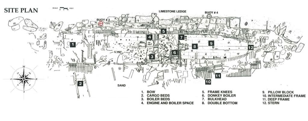
. The labeling of the bouys on the pdf is incorrect. The anchor/plaque is between 4th and 5th buoys counting from the South. Once you find the Anchor/Plaque just swim North and you will find the wreckage. There is some wreckage that extends over the sand (good area for macro photography) that is just North of the Anchor/Plaque but I would swim along the line where the reef meets the sand and you will come across it.

About 2 years ago I was kayaking there regularly for macro photography and I am certain that the anchor was between the 4th and 5th bouy becaue I returned there several times by counting bouys as I approached from the South. I see that soamelt says the anchor is between the 3rd and 4th bouy. If this is the case then one of the Southern most bouys must have broken loose within the last 2 years.
 
Also, as Chug said it's pretty flat. Your not going to see a big ship sticking up -

PICT000218.JPG
 
Curious how things can be so different just 2 miles away and 2 hours earlier.
I went off of the beach at 12th street just south of Atlantic Boulevard.
We hit the water at about 8:15 am and slowly worked our way out to the drop off and hit 27'.
We had blue-green water and 30'-40' viz.
There was a current from the south upon entry but it flipped direction back and forth a few times.
We caught 7 bugs but only 4 came home due to shorts.
We had 2:35 bottom time and spent probably 45 minutes on top just talking and screwing around.
It was flat calm in the morning and 6" waves upon exit exactly where we walked in.
It was a good day.
I will be beaching it again this Saturday.
Sunday is picnic and beach clean-up at John Lloyd Park in Dania.
Chug

That's where I went out also. Do you go out with meet up group @ El Ray's? I probably got in the water about around 9:30 or so. We went straight out to the drop off, headed south against the current for about 35 minutes, then let the current take us back north. We then kicked back on top to the broken reef and were going to head south on the reef. After we dropped back down, there wasn't that much reef as far north as we were and fought the current for 20 minutes checking out the sand before ending the dive.

I'll be back out Wednesday night and either Saturday or Sunday.
 
https://www.shearwater.com/products/swift/
https://xf2.scubaboard.com/community/forums/cave-diving.45/

Back
Top Bottom