CT-Rich
Contributor
Mike and I went to FTW today. We were originally going to dive Newport, but there was a small craft advisory. The wind was heading out of the NorthEast, which usually bodes well for shore diving, but, not when it is 15 knots.
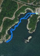
Our first dive we went along along the Western wall of the sandy beach cove. Visibility was surprisingly good. I kept our depth above 30 fsw as we came to edge of the cove. We ended up entering a little valley where the rock face cleaved away from the mainland. Because the water was very flat there was little surge. Lots of Tautaug were hanging out. I followed the valley to where it opened back to open water. I had assumed Mike was right behind me. When I looked back he wasn’t there. I saw his light waving back and forth in the distance. Rushing back I discovered him struggling with the float line. It was caught up on the rocks near the entrance of valley. We were already at our turn pressure anyway so we headed back. 64 minutes, max depth 34’, water temp 67F, visibility 10’
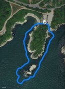
Our Second dive was around the point from the boat ramp to the goat path. We kept to a depth of a 31’ most of the way around, but we dip down to 40’ a couple of times. This is a good depth because you can do the whole distance in about an hour (54minutes). Deeper is a longer distance using more air. Lots of fish life out at the point. I was hoping we would see some schooling stripers all the way out, but this time there were none. We were in the water right after high tide, so there was almost no current, which can get ripping at times. 54 minutes, max depth 41’, water temp 67F, vis 5-10’

Our first dive we went along along the Western wall of the sandy beach cove. Visibility was surprisingly good. I kept our depth above 30 fsw as we came to edge of the cove. We ended up entering a little valley where the rock face cleaved away from the mainland. Because the water was very flat there was little surge. Lots of Tautaug were hanging out. I followed the valley to where it opened back to open water. I had assumed Mike was right behind me. When I looked back he wasn’t there. I saw his light waving back and forth in the distance. Rushing back I discovered him struggling with the float line. It was caught up on the rocks near the entrance of valley. We were already at our turn pressure anyway so we headed back. 64 minutes, max depth 34’, water temp 67F, visibility 10’
Our Second dive was around the point from the boat ramp to the goat path. We kept to a depth of a 31’ most of the way around, but we dip down to 40’ a couple of times. This is a good depth because you can do the whole distance in about an hour (54minutes). Deeper is a longer distance using more air. Lots of fish life out at the point. I was hoping we would see some schooling stripers all the way out, but this time there were none. We were in the water right after high tide, so there was almost no current, which can get ripping at times. 54 minutes, max depth 41’, water temp 67F, vis 5-10’