Has the SS North Pacific been found?

Please register or login

Welcome to ScubaBoard, the world's largest scuba diving community. Registration is not required to read the forums, but we encourage you to join. Joining has its benefits and enables you to participate in the discussions.

Benefits of registering include

  • Ability to post and comment on topics and discussions.
  • A Free photo gallery to share your dive photos with the world.
  • You can make this box go away

Joining is quick and easy. Log in or Register now!

Cthippo

Contributor
Messages
951
Reaction score
1,221
Location
Bellingham WA
# of dives
25 - 49
This is one of those "This should be easy, but isn't" things.

The SS North Pacific was a sidewheel steamer that sank off Marrowstone Island in 1903 after striking Craven Rock in the fog. Records indicate she sank in 15 fathoms of water.


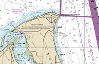
Ok, we know where Craven Rock is, and the 15 fathom curve is pretty narrow around there. There is NOAA bathymetry data for the area, so it should show up clearly, right?

Yeah, no.

So, I'm wondering, does anyone know if this wreck has been found or of it was salvaged, or destroyed as a hazard to navigation?
 
People have been looking for the North Pacific for 30+ years. With way higher resolution sidescan than the NOAA multibeam. Has not been found.

I have a possible target in my long term "to-do" list but really not very motivated to get VTS permission to dive it. Nevermind the fact that we have no more qualified skippers to run high current charters in the VTS lanes. Being at 200+ and beyond the fun zone doesnt help my mojo
 
Wow, she must have drifted a long ways after coming off the rock then.

Nice to know I'm not the only one struggling with this one.
 
Being at 200+ and beyond the fun zone doesnt help my mojo

uh yeah, that would be bad juju for me too. :-]

I've been looking for any evidence while diving in the area. The only thing that comes to mind is the big anchor at the north end of the fish haven at Flagler, but I don't know if it's related.

Anchor Video
 

Attachments

  • marrowstone.png
    marrowstone.png
    330.1 KB · Views: 41
g2:
uh yeah, that would be bad juju for me too. :-]

I've been looking for any evidence while diving in the area. The only thing that comes to mind is the big anchor at the north end of the fish haven at Flagler, but I don't know if it's related.

Anchor Video
Have you dove Craven rock itself? I am thinking about what Bob Ballard said about finding the Titanic and Thresher. Basically they found the debris field and followed it to the wreck. We know she hit the rock, and so I'm wondering if there might be a debris trace to follow.

I guess a next step is to find the court of inquiry records and maybe try to come up with historic tide charts to get an idea of the timeline of the sinking and the currents that day.
 
Have you dove Craven rock itself?

Not yet. It would need to be via boat since there's no public access nearby. It's also exposed to the straits, so currents can be rippin' if you mis-time it. Once there, having a DPV would be good because you'd need to cover a lot of ground and get back fighting the inevitable current. (Sounds like fun actually, I just need a bigger boat.) So access and timing are problems.

Got a big enough boat for all the gear and either a heavy anchor or qualified driver to follow us? Let's go!
 
Have you dove Craven rock itself? I am thinking about what Bob Ballard said about finding the Titanic and Thresher. Basically they found the debris field and followed it to the wreck. We know she hit the rock, and so I'm wondering if there might be a debris trace to follow.

I guess a next step is to find the court of inquiry records and maybe try to come up with historic tide charts to get an idea of the timeline of the sinking and the currents that day.
Probably 50+ "targets" have been dropped along that shore over the years. There's no debris field, probably because: 1) nobody knows which rock she actually struck 2) she was made of wood and 3) she's now 120 years old. Go try to find the old minesweepers off Point Jefferson or in Colvos Passage. They are nothing but woodchips at best. The keel and rocking arm and a few other larger denser bits might remain but they won't look like much unless you have a very good sidescan.

There's nothing special about Craven Rock.
 
The keel and rocking arm and a few other larger denser bits might remain but they won't look like much unless you have a very good sidescan

I would think the stack and boiler would still be around. Not sure how you'd positively identify the vessel from them unless there was a plaque, but something should still exist.
 
g2:
I would think the stack and boiler would still be around. Not sure how you'd positively identify the vessel from them unless there was a plaque, but something should still exist.
The annoying thing about that stretch of shoreline is there are 100s of rocks that are "boiler" sized lol.

I guess I wasn't clear, any possible small stuff that broke or fell off that would make a "debris field" is long rotted away. So yes there's probably a boiler, the keel wood, ballast stones (?) and perhaps some other parts that could eventually be IDed if found
In my experience side wheelers come apart on the surface and sink over a very large area. We found the Keystone State in 2013 and her debris trail stretched over a half mile in 160+ ft of water. The Lady Elgin is spread out over 5 square miles. In Salt water you'd be better dragging a magnetometer than a side scan or a camera sled.

Screenshot_20231010_195509_Cloud.jpg

Screenshot_20231010_195440_Cloud.jpg
 
https://www.shearwater.com/products/teric/

Back
Top Bottom