driftwood
Contributor
Robert, Lake Travis Scuba, Wendy and I had a nice day on Lake Travis that answered a lot of questions.
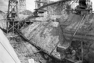
First, I had to identify a hill seen in one of the LCRA archive photos to make sure that the picture was from the Mansfield construction site and not another Highland Lake. At one specific angle, the hill behind Hippie Hollow is a perfect match.
Second, we found a very old cistern off the east side of Sometimes Islands. Roughly 5-6' in diameter and 8-10' deep. The lip is made of cemented limestone blocks and the cistern looks like it is lined with plaster. Next to the cistern is the wreck of a speed boat that still had its inboard V-8 engine in place. Guess that he found the little hill the cistern sits on before we did. At the current lake level, the cistern and boat are just breaking the surface.
Third, we spent some time at the Shaker Plant site trying to get a better feel for the positioning of the artifacts that remain. Wendy and me dove a good portion of the wall at depths between 20 and 45'. Saw some of the timber structures but more importantly got a firm location on the broken concrete slab and the pipe that I have seen in archive photos.
The next step will be to do further systematic searches from 30 to 50'. Once we have a grid filled in then we can start shooting buoys to the surface to get GPS readings and to lay line for a scuba trail. When the lake rises back to a normal pool elevation of 681', the trail will remain at recreational depths.
While the lake is down, this is a perfect opportunity to see what is at around the 530' elevation (currently, roughly 100' deep ). The bases for the conveyor belt system, the rock crusher, mixing and loading station for the tram buckets are at this depth. Personally, I haven't been that deep, but from what I have seen in the archives, there could still be a lot down there to discover. I think that we ran across a large grotto on the wall very close to the loading station at the southern end of the Shaker Plant Site.
I had a great time today and a decent beginning to a worthwhile project has been made. Thanks to Robert and Wendy for making it happen.
Last edited: