Eric Sedletzky
Contributor
Diving unknown spots and adventure is what I'm all about. This is what I live and dive for. How do you think new spots get discovered and become regular dive sites? someone has to be the first one to dive the spot, good or bad, and I'm the guy who does that.
I have a skiff I built and I dive with a small group of explorers. What we normally do is study a typo map on my computer from a garmin program. I find an area with some interesting bottom structure and record the coords on my gps. Then we will go to that site. The maps are not that accurate so most times we have to motor around to find the pinnacle or structure. I punch in many gps coords all around the area and also record the depths; iI use this info later to make my own map of the site. When we finally anchor to go down and take a look, if it's an offshore site vulnerable to currents I will sometimes leave someone in the boat. When we go down the anchor line I will clip off a reel into the chain and we will head off and check it out. Even though we are pulling a reel line, we keep an eye on a compass to record what direction we were travelling. If we have enough air left we either clip off another reel and keep going, or return to the anchor and head off in another direction still pulling line. The line allows us to return to the anchor line every time. We will do many dives on the same site to map it.
On stuff closer to shore I look for things like a small isolated kelp paddy that usually means a rocky structure. I use my bottom sounder a lot. That is one of my main tools for finding new sites. I also look at the shoreline structure. Generally when a ridge goes out into the ocean and forms a point, you can almost bet that it's going to form a similar pattern underwater. These usually are dynamic dives with lots of life and structure.
I also kayak dive quite a bit. I have a small hand held depth finder that looks like a flash light . You simply point it straight down into the water and push the button and it will give you an instant readout of your depth.
For shore diving I have been known to hike to some very remote and hard to get to sites just because the ocean looked like it held underwater promise. I was usually right. I think many times we are the first ones to dive these spots because nobody in their right minds would pack gear that far just to do an unknown dive, but we will.
I have dove so many odd places that others would never even consider just to see what's there. Many of them I have no reason to go back, but I at least can say I've been there dove that.
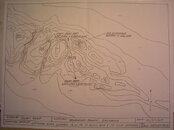
The attached pic shows what one of my typical maps looks like.
I have a skiff I built and I dive with a small group of explorers. What we normally do is study a typo map on my computer from a garmin program. I find an area with some interesting bottom structure and record the coords on my gps. Then we will go to that site. The maps are not that accurate so most times we have to motor around to find the pinnacle or structure. I punch in many gps coords all around the area and also record the depths; iI use this info later to make my own map of the site. When we finally anchor to go down and take a look, if it's an offshore site vulnerable to currents I will sometimes leave someone in the boat. When we go down the anchor line I will clip off a reel into the chain and we will head off and check it out. Even though we are pulling a reel line, we keep an eye on a compass to record what direction we were travelling. If we have enough air left we either clip off another reel and keep going, or return to the anchor and head off in another direction still pulling line. The line allows us to return to the anchor line every time. We will do many dives on the same site to map it.
On stuff closer to shore I look for things like a small isolated kelp paddy that usually means a rocky structure. I use my bottom sounder a lot. That is one of my main tools for finding new sites. I also look at the shoreline structure. Generally when a ridge goes out into the ocean and forms a point, you can almost bet that it's going to form a similar pattern underwater. These usually are dynamic dives with lots of life and structure.
I also kayak dive quite a bit. I have a small hand held depth finder that looks like a flash light . You simply point it straight down into the water and push the button and it will give you an instant readout of your depth.
For shore diving I have been known to hike to some very remote and hard to get to sites just because the ocean looked like it held underwater promise. I was usually right. I think many times we are the first ones to dive these spots because nobody in their right minds would pack gear that far just to do an unknown dive, but we will.
I have dove so many odd places that others would never even consider just to see what's there. Many of them I have no reason to go back, but I at least can say I've been there dove that.
The attached pic shows what one of my typical maps looks like.