Cthippo
Contributor
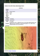
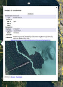
Shipwrecks and derwlict vessels have been a passion of mine my entire life, and I have been keeping various iterations of wreck databases for years. I've had a whole lot of down time this winter and am using that time to standardize, integrate and clean up my database and now I would like to share it. The data comes from many sources and mostly focuses on Puget Sound wrecks and derelicts.
So the question is, how best to share it? Riggt now it is in a Google Earth .kmz format, which is not especially conducive to conversion to a website. I could create a site and just post the most current version of the .kmz along with change logs and links for the attached images.
Is there a better way? What would people find most useful?