You are using an out of date browser. It may not display this or other websites correctly.
You should upgrade or use an alternative browser.
You should upgrade or use an alternative browser.
Scuba Sextant
- Thread starter Venskj
- Start date
Please register or login
Welcome to ScubaBoard, the world's largest scuba diving community. Registration is not required to read the forums, but we encourage you to join. Joining has its benefits and enables you to participate in the discussions.
Benefits of registering include
- Ability to post and comment on topics and discussions.
- A Free photo gallery to share your dive photos with the world.
- You can make this box go away
Venskj
Registered
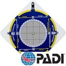
The Aqua Bearing Buddy is a step in the right direction, but it still seems to require you to swim specific headings (i.e. 45 degrees). The thing I'm looking for I think may have even come from PADI. The last time my LDS checked their catalog, it was no longer in it. Bummer.
I'll keep watching eBay I guess.
I'll keep watching eBay I guess.
post a request in the classifieds. maybe someone has one they will part with.
Venskj
Registered
GREAT IDEA! I still stumble around SB. I didn't think of the classifieds. Thanks.
---------- Post added April 2nd, 2013 at 03:29 PM ----------
Exactly. Thanks.
---------- Post added April 2nd, 2013 at 03:29 PM ----------
Exactly. Thanks.
Gatortag
New
GREAT IDEA! I still stumble around SB. I didn't think of the classifieds. Thanks.
---------- Post added April 2nd, 2013 at 03:29 PM ----------
Exactly. Thanks.
I'm surprised many don't know about this. It is a fantastic tool to map a dive site and supplements and relies upon a good compass (it's not a substitute for it). All you need to do is keep track of your heading and distance (time, kick cycles, whatever) and as you pass certain features you just note it (I write on the back and number the description and location along the particular leg that I am on). Once you are back on shore, you can map out the legs and add the features you noted at the appropriate places. The fact that you can follow any path you want as long as you keep track of the various paths/legs and allows you to go where ever you see something of interest rather than have to follow a pre-determined course/legs. You can also do as many different legs and you don't need to have sophisticated tools to get back to where you started - all you need to do is "close the polygon" you created and voila, you are back at the start. Once you close it, everything you saw and noted on your path is now accurately placed relative to each other and you can create a very accurate map as a result.
One note. The better one is the Scuba Sextant, not the Padi Navfinder, because the larger the area to record your travels the more accurate the results. The Navfinder has a lot of extra, unnecessary stuff and the graph area is that much smaller.
Have fun with it.
oldschoolto
Contributor
And here I was thinking you're looking to get a sextant & star charts for night diving....
Jim.....

Jim.....
covediver
Contributor
looks like my old E6B navigation computer from my private pilot ground school. What a great idea. Had no idea that these things existed for diving. could be fun and educational. thanks for posting
Rich Keller
Contributor
Technology nerds would think that this concept could be updated with solid-state gyroscopes for inertial navigation.
Real technology nerds would think this concept could be improved with an infer red line scanner.
Similar threads
- Replies
- 12
- Views
- 1,018
- Replies
- 0
- Views
- 117
- Replies
- 4
- Views
- 824
- Replies
- 22
- Views
- 3,023


