Atlantis Dive Resorts
Registered
Atlantis Azores Captain’s Log March 16 – 22, 2014
Tubbataha Itinerary
Weather: Sunny all week, beautiful full moon throughout the evenings.
Seas: A little bumpy on the ride out, beautiful conditions the rest of the week.
Water temp: Hovering at 28 C / 82 F
Log entry by Capt’ Todd
As we were preparing for a “down week” a funny thing happened, we picked up a charter! It seems there was a group from the University of Queensland that had been waylaid in their efforts to secure a vessel for a research trip to the Atolls and we somehow crossed paths. To their delight they wound up on Azores this week to fulfill their mission. Led by Pete and Ben, both research scientists, they had the help of a handful of student researchers and a group representing the TMO (Tubbataha Management Office).

We headed out mid afternoon Sunday and arrived at the “middle grounds” around daybreak Monday. Loaded with SIGNIFICANT amounts of scientific equipment, most of it sophisticated photo apparatus; the team got busy assembling and was ready to start “mapping” areas throughout the Atolls, starting at Amos Rock and all areas adjacent.
Tuesday we headed to the south end of South Atoll and got the entire area mapped within a day, allowing us to venture north the next morning.

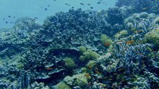
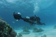
Wednesday the group got busy covering the area near Black Rock and then we moved up to the Malayan Wreck area and proceeded up the west coast there. This amazing camera they have takes sequenced photos from a variety of angles and is propelled by a human guided “rocket” (see photo) that allows them to cover extensive amounts of terrain. The end result will be something like a “Google Street View”, only it will be from beneath the ocean’s surface and covering most of the reef here at the Atoll (perhaps allowing for a “virtual tour” of this place!)

Thursday we documented the entire NE portion of the Atolls and then headed to Jessie Beasley Atoll early Friday. The Atoll there was “revealed” in no time and we were on our way home by noon.
We’re looking forward to the end result of all this effort one day, and when we can see it, so will you! (We’ll post it!). Good Luck to the team, as they’re off to the Solomon Islands next where they’ll be mapping more underwater terrain and hopefully making it available for the entire world to see in the near future.

Tubbataha Itinerary
Weather: Sunny all week, beautiful full moon throughout the evenings.
Seas: A little bumpy on the ride out, beautiful conditions the rest of the week.
Water temp: Hovering at 28 C / 82 F
Log entry by Capt’ Todd
As we were preparing for a “down week” a funny thing happened, we picked up a charter! It seems there was a group from the University of Queensland that had been waylaid in their efforts to secure a vessel for a research trip to the Atolls and we somehow crossed paths. To their delight they wound up on Azores this week to fulfill their mission. Led by Pete and Ben, both research scientists, they had the help of a handful of student researchers and a group representing the TMO (Tubbataha Management Office).

We headed out mid afternoon Sunday and arrived at the “middle grounds” around daybreak Monday. Loaded with SIGNIFICANT amounts of scientific equipment, most of it sophisticated photo apparatus; the team got busy assembling and was ready to start “mapping” areas throughout the Atolls, starting at Amos Rock and all areas adjacent.
Tuesday we headed to the south end of South Atoll and got the entire area mapped within a day, allowing us to venture north the next morning.

Wednesday the group got busy covering the area near Black Rock and then we moved up to the Malayan Wreck area and proceeded up the west coast there. This amazing camera they have takes sequenced photos from a variety of angles and is propelled by a human guided “rocket” (see photo) that allows them to cover extensive amounts of terrain. The end result will be something like a “Google Street View”, only it will be from beneath the ocean’s surface and covering most of the reef here at the Atoll (perhaps allowing for a “virtual tour” of this place!)

Thursday we documented the entire NE portion of the Atolls and then headed to Jessie Beasley Atoll early Friday. The Atoll there was “revealed” in no time and we were on our way home by noon.
We’re looking forward to the end result of all this effort one day, and when we can see it, so will you! (We’ll post it!). Good Luck to the team, as they’re off to the Solomon Islands next where they’ll be mapping more underwater terrain and hopefully making it available for the entire world to see in the near future.


