It is tough to put the currents on a dive map as it is the ocean and things do change. A particular dive site may have "Prevailing" currents that are often from one direction, but on any given day or at a given time of day may change.
Example 1 Dive site currents may be tidal in nature (Washington State for example has some great dive sites around Oak Harvor, Port Townsend, Evertt etc). This is at the top of Puget Sound. The tides create a very strong current in this area. So the prevailing current is different depending on the tide.
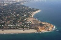
Example 2: In Southern California a dive site at Point Dume (see photo). This is an excellent place to dive, but a very difficult place to dive. Long swim, we are talking 450 yards or so, Now the current (prevailing) is normally from the north (in the photo below you are looking towards the South). This means that you have the current helping you get out, and swimming against it to get back. Lifeguards often rescue SCUBA divers who can not get back. As you can see from the photo you have tall clifts and a very small beach (not visible in the photo) past the point for an emergency bailout (then a nice hike up steps over the 100+ foot point) if you can't get back to the beach you left from. If you miss this postage stamp bail-out beach, then the next location without a verticle cliff face right at the water's edge is about a mile or more to the south. So the "prevailing current" is from the North, but I have dove it where I had to fight the current coming from the south to get out. So currents can change.
So I only expect a map of a dive site to show me the area, great spots to visit, and maybe the bathymetric map of the bottom. Your dive training recommended that you hire a dive master or find someone very familiar with the local diving when you go to a location you are not familiar with. The above is the reason why. Monastery Beach, Monterey California for example is locally called (and signs posted that say this) Mortuary Beach, as it is a terrific dive site, but a killer. The beach has signs posted with the number of deaths there.