cozcharlie
Contributor
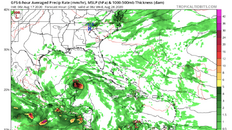
Cozumel really needed more stuff to worry about Top graph is obviously from National Hurricane Center. Bottom charts are from GFS model courtesy of Tropical tidbits. GFS shows both systems coming over/very near Cozumel—first Sunday and second late next Tuesday
PLEASE NOTE THIS DOESN’T MEAN THERE IS A HIGH LIKELIHOOD A HURRICANE WILL ACTUALLY HIT. I certainly wouldn’t cancel a trip just yet. Just flagging as something to watch. This is just one model (Probably not even the best model, just one of the most widely available ) and it normally changes quite a bit when they run it every 12 hours, but unfortunately it tracks both storms right into Cozumel as of last model run. This far out in time tracks can be off by several hundred miles (maybe even 1,000). The intensity forecast is probably even harder to gauge that far out (could dissipate and be nothing or strengthen and be a real pain).
All this means is that I will be checking internet even more than I already do this week

Looks like the closer storm would pass by Sunday on GFS model. It just shows pressure at 1005mb-that’s not very low (think wave/depression/weak tropical storm )

The second storm could be a real problem. 967 millibars (Somewhere around Cat 2/3 Hurricane )

Pressure and windspeed conversion (NHC)
[https://www.ssd.noaa.gov/PS/TROP/CI-chart.html]
tropical tidbits (has weather model runs ) Change the region to the western Atlantic when you look at models
[Tropical Tidbits]
PLEASE NOTE THIS DOESN’T MEAN THERE IS A HIGH LIKELIHOOD A HURRICANE WILL ACTUALLY HIT. I certainly wouldn’t cancel a trip just yet. Just flagging as something to watch. This is just one model (Probably not even the best model, just one of the most widely available ) and it normally changes quite a bit when they run it every 12 hours, but unfortunately it tracks both storms right into Cozumel as of last model run. This far out in time tracks can be off by several hundred miles (maybe even 1,000). The intensity forecast is probably even harder to gauge that far out (could dissipate and be nothing or strengthen and be a real pain).
All this means is that I will be checking internet even more than I already do this week
Looks like the closer storm would pass by Sunday on GFS model. It just shows pressure at 1005mb-that’s not very low (think wave/depression/weak tropical storm )
The second storm could be a real problem. 967 millibars (Somewhere around Cat 2/3 Hurricane )
Pressure and windspeed conversion (NHC)
[https://www.ssd.noaa.gov/PS/TROP/CI-chart.html]
tropical tidbits (has weather model runs ) Change the region to the western Atlantic when you look at models
[Tropical Tidbits]