OML/Terranea closed for 30 days

Please register or login

Welcome to ScubaBoard, the world's largest scuba diving community. Registration is not required to read the forums, but we encourage you to join. Joining has its benefits and enables you to participate in the discussions.

Benefits of registering include

  • Ability to post and comment on topics and discussions.
  • A Free photo gallery to share your dive photos with the world.
  • You can make this box go away

Joining is quick and easy. Log in or Register now!

Max is right, IT IS CLOSED!


...some divers didn't hear about the closure, they were then let in by a (new) guard this morning that didn't hear about the closure either. The divers called me to ask why it's a ghost town today? Haa! I said "we'll be right over if the guards say so", and that's how it happened...

I'm sure I'll hear about it on Monday ;~)

What is your affiliation with Turner/OML/Terrania?
 
Don is our dive liason. He has been working with RPV City Hall, Long Point Associates, Turner Construction and Terranea to keep our access as open as possible. He was responsible for the gate code in the original lot, and he led our beach cleanups each week to make sure we were kept in their good graces.
 
Saw a dive charter out in the sandbar outside the "120 Reef", weird?? I would have anchored at Long Point, waaay better diving!

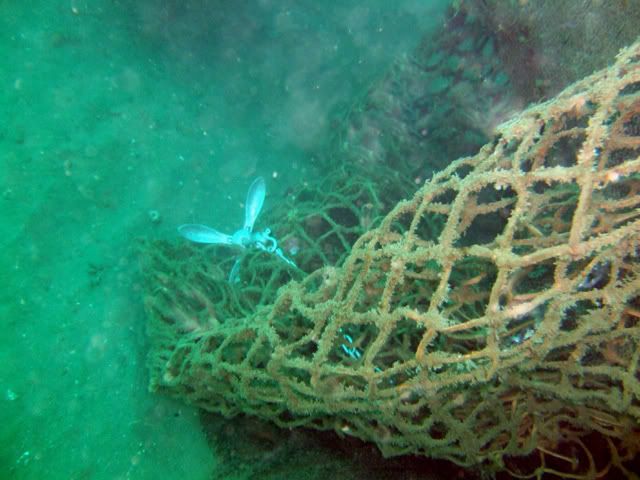
That was probably us on the Sea Bass Don. We were on the "platform", some wreckage left over from the Marineland pier. Had some netting wrapped around it in parts. It is a small structure on the sand at 70 feet. Viz was poor and only a few of us found it. Our other dives were outer Hawthorne Reef and Xmas Tree.
 
Saw a dive charter out in the sandbar outside the "120 Reef", weird?? I would have anchored at Long Point, waaay better diving! As they pulled out Gary Jackson and the Psalty V pulled in to dive the "Jenny Lynn" wreck with Cal Wreck Divers. She's at about 140' off Long Point, hope to see it next week with ODA. Apparently it's covered in nets, yuk! Nice day out there!

That probably would have been us. We were on on the Sea Bass and the captain had the bright idea to drop us there onto the Old Marineland Platform, or so he claims. Almost everyone found some sand, some silt, and the occasional other diver who was lost in sand and silt. What a bust of a dive...


someone mentioned "Christmas Tree" and "Honeymoon" in an earlier post...can you or others elaborate with details? i've been diving my dubs at Vet's for the last 2 years and frankly i need a change so am getting back into some more single tank diving and looking for good spots close to LA. i was with Rainer and Liger at OML and loved it...

thx!!

Christmas Tree Cove has even worse access than OML....and to top it off, the diving is only okay. There are far better sites to do singles dives around here. LMK when you and Rainer want to go out again and we'll find some other singles friendly dive sites....Laguna, PV, Malibu....they can be found. You don't have to go out to 100 feet at Vet's to have fun! :wink:


That was probably us on the Sea Bass Don. We were on the "platform", some wreckage left over from the Marineland pier. Had some netting wrapped around it in parts. It is a small structure on the sand at 70 feet. Viz was poor and only a few of us found it. Our other dives were outer Hawthorne Reef and Xmas Tree.

Don't be silly, there was no platform....just sand (lots of it....lots of silt). Ugh!

But Hawthorne was SPECTACULAR!
 
Yes Nicole, there is a platform. :)
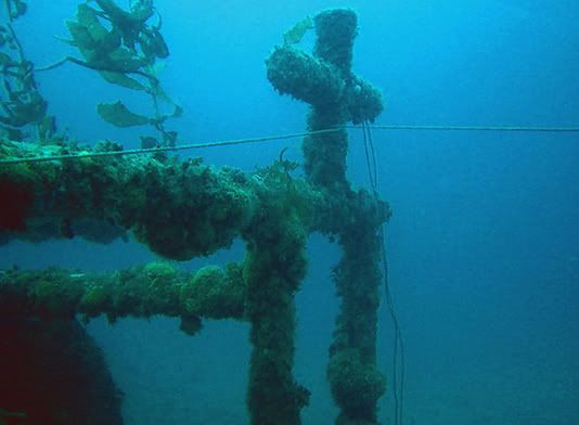
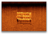
It's a no-longer-floating fuel dock. It was once straight out from Cobble Beach, but a couple of years ago a boat dragged it to it's present location. It's about 30 X 40 feet, so it's easy to miss in bad vis. Nearly every inch of it is covered by hydroids, nudibranchs, crabs and bryozoans. It was originally found by Jim McCabe (McCabejc) and Christian Lopez (Headhunter on Scubaboard) on 02/06/2005, but neither of them knew exactly where it was located.
http://www.scubaboard.com/forums/socal/86205-feb-05-dive-reports-2.html#post951819
I took their descriptions and estimates and made a grid to check out. Jeff Shaw and I made more than a dozen dives looking in the areas where it was suspected to be without luck. One day I was in the area and spotted a tire, then some netting, then the platform itself! I surfaced to take lineups and was shocked at how far offshore it was. I went back the next day, 6/25/05 to lay the lines and set a float, and all of a sudden we had something new to explore at Marineland. I laid new line and a float to it's current location from the beach on 10/26/06, but someone kept removing each float I set. Eventually the line deteriorated as well.
Platform-1.jpg


DSCF1631.jpg


008.jpg


030.jpg


010.jpg


page72_20_1.png
 
Yes Nicole, there is a platform. :)

hehe, are you sure you didn't fabricate those pictures to try to pass them off as the platform? :wink:

Did you shore dive and surface swim (or swim underwater) all the way out there? Or were you diving from a boat? That would be an excessively long swim! I wish I had found it....but I probably won't try again....I'll probably stick with places I KNOW I'll find stuff :D
 
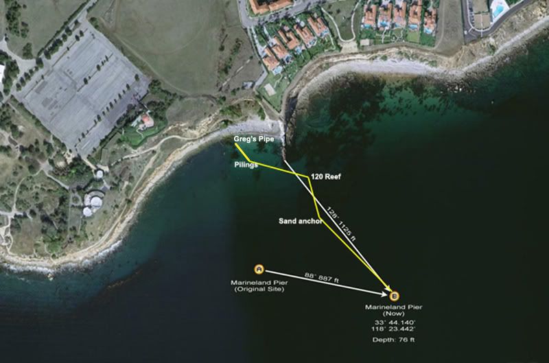
I was on Ross' boat when Elaine took her pictures, but the rest of the dives were from the beach. When it was in the first location we swam out and back underwater once I had the line in place. From it's current location we used to surface swim out to the buoy, then swim slowly back underwater to conserve enough air to make it all the way back. The line went from one of the crosses on top of the platform to a sand screw a few hundred feet inshore, then to the outer edge of the 120 Reef. From there the line went across the cove to Greg's Pipe, about 20 feet from the exit spot. It was about a 1/4 mile trek, the same as the cove to the point swim.
Linemap-2.jpg

The yellow line represents the cave line I placed from the platform to Greg's Pipe. Note how far the platform was dragged from it's old spot.

Phil_Claudette_sdive.jpg

This was the path Claudette and I took on the first dive after I laid the original line. We swam out to the yellow X, where I tied one end of the line, then out to the platform. We tried to take the excess line all the way to the 120 reef, but there wasn't enough line. We did come across a cute little octopus in the sand hiding behind a small piece of kelp. We exited in the cave, or should I say we were bounced into the cave. Claudette said she looked back as the water receded and saw a massive wall of gravel headed our way. We were pounded, but escaped with only our dignity lost.
 
"What is MY affiliation with Turner/OML/Terranea?"

I live the closest to Turner/OML/Terranea. They call me to try to let the diving community know about inconvenient closures to this site. Hope they help?
 
Last edited by a moderator:
"What is MY affiliation with Turner/OML/Terranea?"

I live the closest to Turner/OML/Terranea. They call me to try to let the diving community know about inconvenient closures to this site. Hope they help?

Thanks Don, I was curious how you got the inside loop on this. Do they have an exact date to reopen the beach? I'm looking forward to seeing the finished product. It will be great when we all get to enjoy it!
 
https://www.shearwater.com/products/swift/

Back
Top Bottom