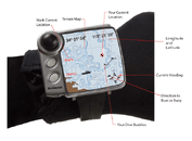
Underwater Navigation Device

Please register or login

Welcome to ScubaBoard, the world's largest scuba diving community. Registration is not required to read the forums, but we encourage you to join. Joining has its benefits and enables you to participate in the discussions.

Benefits of registering include

  • Ability to post and comment on topics and discussions.
  • A Free photo gallery to share your dive photos with the world.
  • You can make this box go away

Joining is quick and easy. Log in or Register now!

I knew a local diver here use to carry his hand held GPS unit in a waterproof case and would pop it to the surface with a small amount of air and then pull it back down again and it would record the last known coordinates, which he would then save into his favorites to find the location again later by boat to re-dive it.
 
I once took my Garmin E trex GPS u/w, It worked, but only down to a depth of 2'...

GPS, Radio's, all pretty much work by "line of sight" if there is something in the way, a signal can be weak, or no signal at all...a good example: you are in a car on the ground in NYC trying to get a 2-way radio signal with your buddy who is outside the city, it would be pretty hard to get a firm signal with all the buildings, but if you are in an open field the signal can travel from one device to the other with no interference... Another example: when aircraft are in flight they can pick up ATC (air traffic control) radio signals from hundreds of miles away, thats because when they are at (for ex) 35,000' there is no obstruction in the way to block signals from a tower that is 150 miles away etc... But, with the case of a GPS u/w the signal is hard to penetrate the water's surface do to reflection, and even if it could, there's still refraction that would screw up the signal.... there is nothing wrong with using a compuss, and fin kicks to get somewhere, and back tracking your route, say you start at a heading of 0 (or 360) degrees (North), go 100 fin kicks, turn left to a heading of 270 degrees (West), go 100 fin kicks, then turn 0 degrees (or 360) (North) and go 200 fin kicks, to get back to the starting point you would head 180 degrees (South) for 200 fin kicks, turn to a heading of 090 degrees (East) for 100 fin kicks, and make a final turn to 180 degrees (South) for 100 fin kicks, and now you are back at your starting point (of course be sure to calculate for current etc...), there are also other ways to determine distance, i.e. time, arm spans, laying a line (measured of course) etc...

Who wants to be counting fin kicks when diving? I don't.
 
then use time, or air supply, or a line
 

Attachments

  • product-shot.gif
    product-shot.gif
    84.4 KB · Views: 866
The Navimate was IMO the coolest new thing at the DEMA Show this year.
 
how about just a plain old compass, and watch (or you can use air supply), or a Reel, and line...

plain and simple... (well mabey not the reel, since they jam/birdnest a lot)
 
how about just a plain old compass, and watch (or you can use air supply), or a Reel, and line...

plain and simple... (well mabey not the reel, since they jam/birdnest a lot)

Maybe YOU don't need to know underwater positions...

Where was that artifact located?

What's the easiest way to lay out a grid?

What exactly was your search pattern?

What is your exact position?

Reels are fine, but even if you drop a shot line on the numbers from the surface... Did the shot drift? How accurate are you?

To SOME people. Accuracy is very important :wink:

Maybe for recreational diving, it's not critical to know your position to within 3 Meters. But depending on what you do underwater... Get it?
 
I agree with HowardE, my average dive is well over 4000 ft from shore and at times is as far as 10,000 linear feet at depths up to 100ft and recording finds is important to me and my dive partners. It is not possible or safe to ascend to get a fix or triangulation in a boat lane. I use a Triton 400 in an otterbox with a reel and have found this to be a good solution to marking locations.
 
The Navimate was IMO the coolest new thing at the DEMA Show this year.

So, was there any info how it works? I was thinking they might hang a sonar transponder off the boat/float that is interrogated by the wrist unit for distance and the GPS data (I presume the GPS is attached to the surface transmitter/transponder), with an incorporated digital compass in the wrist unit to give bearing info, and maybe a depth sensor to correct slant range to range over ground? Or some other method? How were they correcting for temp/salinity, if at all? What kind of accuracy were they claiming? Unfortunately, their website is lacking in details.

Sure would make underwater mapping faster and easier. As it is, we've buoyed waypoints with a DSMB and had a guy in a kayak mark the coordinates with a GPS. Of course, we've also run tautlines and survey tapes between the waypoints to get more accuracy than +-3m when needed for mapping, but if you can get that close you can easily do a small search to find the target.

Guy Alcala
 
Last edited:
https://www.shearwater.com/products/peregrine/

Back
Top Bottom