Scuba diver's Personal Locator Beacon - how never to be lost at sea

Please register or login

Welcome to ScubaBoard, the world's largest scuba diving community. Registration is not required to read the forums, but we encourage you to join. Joining has its benefits and enables you to participate in the discussions.

Benefits of registering include

  • Ability to post and comment on topics and discussions.
  • A Free photo gallery to share your dive photos with the world.
  • You can make this box go away

Joining is quick and easy. Log in or Register now!

great idea.

The first time you are on a boat that capsizes, and you are found due to the beacon, I'm guessing that the other passengers would be happy to reimburse you for the cost :)
 
EPRIBBs/PLBs are the most tried and true electronic way of being "seen". Unfortunately that may still leave you drifting in the water for 3 hours until a satellite passes overhead. Throw in another hour for a rescue ship to depart the dock and arrive at your current position, it could be close to 4 hours later. Outside the US the time delay to departure of a rescue vessel could be even longer.

In the case of the sinking boat, they had such little time, the best place for the unit would be in a pocket on each person. Attached to a BC fixed in a tank mount on a sinking boat isn't going to do you much good. Looking at the size of the canister it appears like it is just large enough you wouldn't want to put it in a pocket?? Where do you plan on storing it?

Is the case you got single or double o-ringed? It sure looks nice :) When you get the PLB please post up more photos so we can see actual size with a ruler or hand in the photo. Thanks for the post!
 
Graphical illustration of the Cospas-Sarsat International Satellite Rescue System Works
sarsat-diagram.jpg


  1. ELTs, EPIRBs, and PLBs operate on the 406 MHz frequency. Each 406 MHz beacon transmits a unique digital code that identifies the type of beacon and that allows registration data to be associated with the beacon. The registration data provides information such as the beacon owner; the type of platform the beacon is associated with; emergency points of contact; and much more.
  2. After the satellite receives a beacon signal, it relays the signal to earth stations referred to as local user terminals (LUTs). There are two types of LUTs: Low-Earth Orbiting LUTs (LEOLUTs) which receive and process alert data from the polar-orbiting satellites; and Geostationary LUTs (GEOLUTs) which receive and process alert data from geostationary satellites.
  3. The LUT processes the data and transmits an alert message to its respective Mission Control Center (MCC) via a data communication network.
  4. The MCC performs matching and merging of alert messages with other received messages, geographically sorts the data, and transmits a distress message to another MCC, an appropriate SAR authority such as a national Rescue Coordination Center (RCC) or a foreign SAR Point of Contact (SPOC).
  5. The RCC investigates the beacon alert and launches assets to find the parties in distress when necessary.


Since its inception in 1982 the Cospas-Sarsat System has provided distress alert information which has assisted in the rescue of 30,713 persons in 8,387 distress situations.
In 2010 only, the System provided information which was used to rescue 2,338 persons in 641 distress situations. The locations of these events are depicted on the map below.

SAR_Events_2010.jpg


System if made up of 11 satellites in 2 systems, the GEOLUTs are able to produce near instantaneous alerting over extremely large areas. However, due to the fact that the satellite remains stationary with respect to distress beacons, GEOLUTs are not able to determine beacon locations using Doppler processing techniques. Therefore the
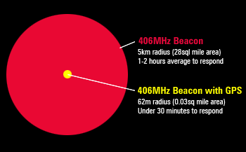
406 MHz distress beacons like the ResQLink transmit their own GPS determined location coordinates to the satellites along with the distress signal.

The graphic below shows the near instantaneous areas of the surface of our planet.


GEOSARDec152011.jpg


This image shows the search area of the ResQLink a 235 foot radius (smaller than the size of two foot ball fields next to each other)

gps-explained.gif
 
PeterC, the 406 MHz system does not rely upon the polar orbiting satellites for detection, As you can see in Mike's post above, GEOSATS should pick up your signal in minutes. I do not have specifics but three or four hours is not likely. My guess is minutes for a SAR agency to know about your PLB activation. That is another question to ask of NOAA.
 
PeterC, the 406 MHz system does not rely upon the polar orbiting satellites for detection, As you can see in Mike's post above, GEOSATS should pick up your signal in minutes. I do not have specifics but three or four hours is not likely. My guess is minutes for a SAR agency to know about your PLB activation. That is another question to ask of NOAA.
It is more at the poles where the delay comes in. Seems they do have the tropics well covered.

"The LEOSAR satellites operate in a store-and-forward mode for 406 MHz signals --- they store distress signals and forward them to the next LEOLUT ground station they overfly. The 6-satellite polar-orbit constellation LEOSAR system provides frequent coverage of the poles with approximately 100 minute orbits."

Still it has to get to a Mexican SAR team before the actual rescue begins. I wasn't knocking a PLB at all, just saying to not expect an aircraft or boat to pick you up 20 minutes later.

The question becomes how many boats in the area can assist in the search, and do they have GPS to be lead to your current location?
 
The question becomes how many boats in the area can assist in the search, and do they have GPS to be lead to your current location?

I would hope if ever required to use the PLB, that you'd be in a location where professional search and rescue assets would be used to find you and they didn't have to rely on private citizens.

In US waters for instance, the coast guard could easily fly directly to you in a helicopter and end up no more than a couple of hundred feet away before they had to rely on a visual search to spot you and lower a basket.
 
I believe that the Mexican Navy is the official SAR agency within Mexico. Could be wrong but not likely.
 
April 10, 2012

Now I have a Custom Diver 200/210 dive canister in my possession it’s time to figure out if the newest ResQLink+ will fit (The floating version is larger) or if it’s going to be the first version the ResQLink which doesn’t float. I’m confident one of them is going to fit; it’s time to figure out which one. Using the specifications from their website I see the standard ResQLink is 3.3cm x 4.8xm x 9.9cm tall. The floating version is a bit thicker and a bit taller; it’s 4.1cm x 4.8cm x 11.4cm tall.

I start by just taking a ruler and trying to measure the inner dimensions of the dive canister. It’s obvious that width and thickness of the unit is not going to be an issue and the crux of this is going to be the height. The standard unit will fit, without a doubt, but the extra height of the ResQLink+ is going to be really tight, I can’t really tell positively anything yet. Problem I didn’t count on is the canister inside height is hard to measure and take into account how much the threads will actually reduce the heights when the unit is joined together and screwed down. We seem to be talking about just millimeters of difference here could determine whether the PLB will fit or not.

Plan B, make an actual sized 3D version of the ResQLink and just put it inside the damn canister and screw it together! That ought to be a surefire way to see if it fits or not. A quick trip to the garage yields a scrap piece of wood and within a few minutes I have a dimensionally accurate (at least in height) doppelganger. I stick it inside and screw the canister together and it fits! It fits snuggly. I shake it, no noise, can’t feel any movement. Wow, there is no room for error what-so-ever. On the positive side I’m thinking that’s a good thing, there will be no worries of the ResQLink banging around inside the canister at any time, that should be a plus, keeping it nice and snug and safe. On the other hand now, I’m looking at the picture of the ResQLink+ that I have printed out and I notice it has two plastic loops at the top and bottom of it. My suspicious mind is starting to wonder just how did they measure their unit to come up with the dimensions? Is the 11.4 cm a true measure of the unit from top of loop to bottom of loop or is that only the measure of the main case of the unit and those loops are not taken into account? If it’s the latter there is no way it will fit.

I figure I’ll try to call the manufacturer and see if I can get some answers. They are in Florida, I’m in Colorado, its 7:30am, and they should be at work. I find their technical support phone number and give them a call. A tech support person named Jack answers and I explain what I’m trying to figure out. He seems to understand the issue and he says to hold on, that he will go grab one, he has a ruler and he will find out for certain. A few seconds later he declares the 11.4 cm measurement includes the plastic loops on top and bottom. Sweet. Thanks Jack!

So I’ve got one canister, I’ve made a dummied up version of the ResQLink and gotten it to fit; I’ve contacted the company and gotten verification of how they measured it. Next step looks like it’s time to order a ResQlink+.

To be continued…

There is a West Marine in Denver. See if they have one in stock and take a ride.
 
I would hope if ever required to use the PLB, that you'd be in a location where professional search and rescue assets would be used to find you and they didn't have to rely on private citizens.

In US waters for instance, the coast guard could easily fly directly to you in a helicopter and end up no more than a couple of hundred feet away before they had to rely on a visual search to spot you and lower a basket.
If you remember the rescue of Abby Sunderland, the 16 year old sailing around the world, it took over 40 hours to just to get to her and it was a French fishing vessel that eventually picked her up. Near shore sure probably will be a SARS unit. Further offshore or in remote areas it comes down to whomever is closest including private boats.

Here in Sonoma County California a SARS rescue by helicopter near shore would be carried out by the local Sonoma County Sheriff's helicopter Henry 1, not the Coast Guard. The CG is too far away. With Rescue 21 installed and operating now they would probably reach out to the closest boats around. Our water is cold enough you have minutes not hours before hypothermia sets in.

The PEPIRB canister you have is looking smaller and more attractive than past options. It will be interesting to see how you mount it. For us an PEPIRB would be a nice compliment to a DSC equipped radio.
 
Last edited:

Back
Top Bottom