Mount storm wv

Please register or login

Welcome to ScubaBoard, the world's largest scuba diving community. Registration is not required to read the forums, but we encourage you to join. Joining has its benefits and enables you to participate in the discussions.

Benefits of registering include

  • Ability to post and comment on topics and discussions.
  • A Free photo gallery to share your dive photos with the world.
  • You can make this box go away

Joining is quick and easy. Log in or Register now!

Like I said, my son an I were there on Labor Day Saturday.

How'd the water temp fall in a few weeks from 90F down to 72F?? Even with cold(er) air, seems like that large a body of water would take a lot longer to cool down.

Hmmm... Never though of doing the surface interval in the water... :D
 
I noticed at the 90ft platform there is a line that runs off one of the corners. Where does this line lead to? Do you know what the real max depth is for that area. I am planning on going up back up there in November and the more info I can get the better. Is there any where to get air fills up there?
 
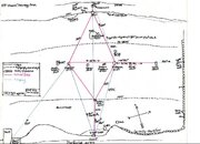
Well, the first map shows that the "deep point" at 128 ft. is in the old streambed (logical), SW of the entrance point.

Which is consistent with what Google Earth shows... The surface of the lake is at 3252 ft., and the streambed just below the dam is at about 3116 ft... an altitude difference of 136 ft. The streambed would be a few feet higher just above the dam, so it makes sense that the lake would be about 128 ft. deep at its deepest point, right up against the dam.

From the map, though, it looks like that marked point is quite a ways away from the base of the dam. Unless the rocks that make up the dam slope that far out? Possible, I guess...

Note this is actual depth, not adjusted altitude diving depth... Adjusted depth would be about... what... 10% more than that?
 
glad i found this thread im trying to talk my instructor/LDS owner into planing a trip up to mt. storm so i can get my deep dives done for my AOW and maybe my navigation too
 
I noticed at the 90ft platform there is a line that runs off one of the corners. Where does this line lead to? Do you know what the real max depth is for that area. I am planning on going up back up there in November and the more info I can get the better. Is there any where to get air fills up there?

That line does run down to a deep point in the trough, which is the original creek bed. I have seen 126 feet at that point, which was on a computer calibrated in FSW, a FFW calibrated computer would probably read 128 feet. Generally once you get below 100 feet at Mount Storm the water changes to a milky white zero vis, the silt is pretty deep down there as well, just following that line, if you pick it up things will start to silt out.

Keep in mind, this is actual depth, which is beyond the Rec diving max depth using theoretical altitude depths. Bottom line, there is nothing to see at elevated risk :no:.
 
Well, the first map shows that the "deep point" at 128 ft. is in the old streambed (logical), SW of the entrance point.

Which is consistent with what Google Earth shows... The surface of the lake is at 3252 ft., and the streambed just below the dam is at about 3116 ft... an altitude difference of 136 ft. The streambed would be a few feet higher just above the dam, so it makes sense that the lake would be about 128 ft. deep at its deepest point, right up against the dam.

From the map, though, it looks like that marked point is quite a ways away from the base of the dam. Unless the rocks that make up the dam slope that far out? Possible, I guess...

Note this is actual depth, not adjusted altitude diving depth... Adjusted depth would be about... what... 10% more than that?

Pretty accurate figuring. Yes the dam does slope out a good ways.

Your adjusted depth would be around 150 feet. Not something to do casually, and without special training, especially in a remote location.
 
For us, using nitrox there wouldn't be worth it at all.

First of all, nitrox fills at our LDS are like twice the price of air.

Second, while you'll certainly visit the 50-ft platform, and might even drop down to the 90-ft platform just to do it, there's really not much to see at those depths that you can't see at 30 ft. So most of your time is likely going to be at +- 30.

Third, you're not going to be doing multi-day diving there -- are you?
 
What are your feelings on using nitrox at storm?

We have been diving nitrox quite a bit lately at Storm. If I was only going to be playing around in the 20 foot platform area I would use air.

I think the most important thing to consider at Mount Storm is the altitude. If you have not done so you should look into an altitude diving course.

The two main issues are giving your self time to acclimate to the altitude upon arrival and realizing that this is the same as ascending from a dive. You now have nitrogen to off gas and dive computers can't compensate for this. You will be doing your first dive with residual nitrogen still in your body.

Then you have theoretical depths at altitude. You need to figure your dive as deeper than it actually is.

Here is wear this can affect nitrox diving. An example at Storm would be a 100 foot dive on 32% nitrox. The MOD (maxium operationg depth) based on 1.4 pp is 111 feet, so you might feel pretty comfortable doing "only" 100 feet. But following theoretical depths this 100 foot dive at 3244 altitude is now equal to a 116 foot dive at sea level. You have now theoretically exceeded the 1.4 pp for 32%, and maybe don't even realize it.
 
Mike is correct. Have quite few dives at Mt Storm myself. Now using another location for OW checkouts that is closer and much nicer with real facilities but for AOW Storm is nice. Warm and don;t have to put students in drysuits for 40 degree water temps. You do have to adjust for altitude but there are easier and less expensive ways than taking a course. Take an OW class that covers altitude adjustments, buy an altitude slate, or get a full copy of v-planner that will alow you to put the altitude in.

When doing advanced courses like my AOW classes we use the altitude table and I will generate contingency tables on v planner whether using air or nitrox. And since we figure it for every dive, since every dive is at altitude, there is no need to use "altitude" as one of the dives. My OW instructor did that and frankly it was waste. There are more valuable things that can be passed on instead of just swimming around and calling it an altitude dive.

As for the map: I made this during my DM mapping project 4 years ago and the headings with my Oceanic compass are correct for it. The ones on my SK-7 are a little different due to compass differences. You also need to correct for current on swims. I do this by swimming a reciprocal off one of the platforms and measuing the amount of drift and just add an intentional error factor in. Many of the intersting things are gone and others have taken their place. And I do know for a fact that the silt is at least 4-6 ft deep in the trench off of the 90 platform. Lonewolf and I measured it one New Years trying to set up a deep nav course. Had 39 inch stakes to put down to tie off to, He had his arm to the shoulder and still had not hit anything solid to put the stake in!
 

Attachments

  • storm map.jpg
    storm map.jpg
    93.9 KB · Views: 80
https://www.shearwater.com/products/perdix-ai/

Back
Top Bottom