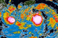
Long range forecast for Matthew
Matthew is being forced just north of due west by a strong ridge of high pressure. This ridge will keep the storm moving at 15 mph through Saturday. On Sunday, a trough of low pressure diving southwards over the Eastern U.S. will weaken the steering currents over the Western Caribbean and cause Matthew to slow to just 5 mph by Sunday night. Most of the models now show Matthew lingering over Central America long enough to dissipate. However, by Wednesday of next week, most of the models indicate that remnants of Matthew, and/or a piece of a tropical disturbance over the Eastern Pacific off the coast of Guatemala, will move into the Western Caribbean and develop into a tropical depression. The trough of low pressure over the Eastern U.S. is then likely to draw this system northwards across Cuba late next week into either Florida or the Bahamas. Whether this development would be called Matthew or Nicole is uncertain, as is the potential strength of such a storm. We'll just have to wait and see what unfolds over the next few days.