Underwater Navigation Device

Please register or login

Welcome to ScubaBoard, the world's largest scuba diving community. Registration is not required to read the forums, but we encourage you to join. Joining has its benefits and enables you to participate in the discussions.

Benefits of registering include

  • Ability to post and comment on topics and discussions.
  • A Free photo gallery to share your dive photos with the world.
  • You can make this box go away

Joining is quick and easy. Log in or Register now!

FWIW, this banner appeared on the Navimate site at Navimate - GPS for Divers a couple of months ago:

We were not able to attend the 2011 DEMA show due to a scheduling conflict,
but we are still committed to bringing Navimate to market in 2012.

I thought I'd wait and see if anything shows up at DEMA 2012 before considering pinging them again.
 
I'll admit I haven't had time to read through everything on NAV Equip on this site, but it seems everyone is fixated on using GPS underwater, you can't, not easily anyway.

However, if you use a low freq DME system which also transmits its GPS position, then the handheld units only have to calculate their position using this information. That data can then either be transmitted back to the base station for dissemination to other units, or directly to other handheld units.
 
I know a little about navigation systems. A GPS nav. base on the boat that you would simply plug into a tiny Ring LASER gyro nav. held by the diver, set to input present position, and a set of way-points to your areas of interest. The 2 or 3 axis gyro would detect motion and acceleration and keep track of position (Inertial Navigation). There have been some major breakthroughs in these packages recently. Prices keep falling.
LASER Navigation beacon? I have worked with ocean penetrating LASER for mapping, but putting data on a fan like emission, is new to me. If you could do that, then sending a homing signal from the boat to the diver may be of some use.
Like radials from the present position of the boat to the receiver in the divers kit. Then only distance would left to the diver. ( And to or from direction).
http://www.gladiatortechnologies.com/DATASHEET/Legacy/LandMark20IMUeXT_DEMO_KIT_datasheet_071009.pdf I am just posting an example of sizes of these units and power requirements. This may not be suitable at all).
 
how bout a dive float with a antenna and or repeater on it to pick up sigal and transmit under the the float...
just an idea as long as it had a pretty decent range you could dive a ways from the float..

dont know enough about underwater but the unit could be on arm or dive console and the main hub on float...

i want royalties now :D

---------- Post Merged at 09:20 PM ---------- Previous Post was at 09:15 PM ----------

lol i just went and read there set up....man they stole my float idea before i thought of it...lol
 
I know a little about navigation systems. A GPS nav. base on the boat that you would simply plug into a tiny Ring LASER gyro nav. held by the diver, set to input present position, and a set of way-points to your areas of interest. The 2 or 3 axis gyro would detect motion and acceleration and keep track of position (Inertial Navigation). There have been some major breakthroughs in these packages recently. Prices keep falling.
LASER Navigation beacon? I have worked with ocean penetrating LASER for mapping, but putting data on a fan like emission, is new to me. If you could do that, then sending a homing signal from the boat to the diver may be of some use.
Like radials from the present position of the boat to the receiver in the divers kit. Then only distance would left to the diver. ( And to or from direction).
http://www.gladiatortechnologies.com/DATASHEET/Legacy/LandMark20IMUeXT_DEMO_KIT_datasheet_071009.pdf I am just posting an example of sizes of these units and power requirements. This may not be suitable at all).

i know this thread is really old at this point -- but was thinking about underwater nav & GPS & INS this morning... saw this thread and i think Lake Muroc Diver is on to something...
Submarines underwater use inertial Navigation systems.

I was thinking of 2 possibilities that would be workable for mapping and the 2nd would be possible to return to the point of origin within a reasonable degree of accuracy.

#1 - use an android phone in a small drybox with an INS app installed. on the surface it will pick up the gps location of the diver before he/she descends. Upon descending, the INS system would allow you to record direction, speed, inclination, etc., working from the GPS location as the point of origin. after surfacing you can extrapolate the route & map it using the inital and ending gps points and the data from the INS.

#2 Builds on the concept of the 1st. either using a tablet in a transparent custom case, or arduino with an LCD & appropriate sensors in a case. could have mapping database preinstalled such as google maps/google earth for real-time display of route. a piano key or something could be used to trigger a waypoint set. there might be a way to connect to the dive computer and get depth, temp, etc reading from it if it accepts a wireless transmitter (which brings up additional possibilities)


What do you think? i've got an old G1 which i'm thinking about seeing if can get an INS app installed on it and trying it out soon.... don't want to risk my newer more expensive phone :)
 
Sigh ... This thread is not just really old, but the OP scubasteve66 created two identically titled threads with identical initial posts back on 11/11/07, this one we're posting in, in the forum General Scuba Equipment Discussions, and also http://www.scubaboard.com/forums/basic-scuba-discussions/209712-underwater-navigation-device.html in the forum Basic Scuba Discussions !!

Worse, both stayed alive for many years, this one last posted to in November 2012, the other in November 2009. That last 2009 post coincided with the announcement of the Navimate, and pointed to it, and then died. This thread lived on with ongoing discussion of the Navimate, which remains vaporware. If nothing shows up at DEMA '13, maybe I'll follow up with what I said above in post 9/24/12 and ping them for status.

BTW, the OP scubasteve66 hasn't been on the board since November 2009, three days after he created these two threads.

With the forum archeology issues outlined, to respond to the substance of the recent posts:

In the other thread starting at post #35 on 10/18/08, user kacem78 suggested an inertial guidance device he was working on. The discussion is technically interesting and goes on for awhile, I expect you'll find it worth reading. Alas, kacem78 last posted there in June 2009 (might be his last post, and shortly before the Navimate announcement) and hasn't been on SB since August 2010.

From the discussion, I believe kacem78 had something working as a prototype. Five years on, I expect that the state of commercially available MEMS devices makes this even more feasible. So you're quite right to suggest it, but I thought I'd connect everyone reading it with the earlier discussion of solving this with inertial guidance.
 
My friend has a Kickstarter called NavDive that is an underwater GPS unit. The campaign is active now if you are interested.
 
I believe Dave, as a new board member, has a problem posting the url. To simplify life for everyone:
NavDive -- GPS-based navigation for SCUBA divers by Kelly Nehowig ? Kickstarter
For the benefit of anyone following this, perhaps years from now:
This Kickstarter campaign failed. 21 backers pledged $2163 out of a $20000 goal.

The principal, Kelly Nehowig, had this statement:
While we did not achieve our overall funding goal, we have received tons of encouraging feedback and we continue to believe that NavDive is a product that is important in specific channels. Based on this feedback, I'm thrilled to announce that we have made the decision to commercialize NavDive and will be offering it for sale via Home [ navdive.com ] in the next few weeks.

What is it? This summary, quoted from the Kickstarter page:
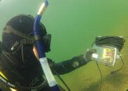
NavDive consists of two main hardware components -- a waterproof GPS receiver that is mounted to the diver's flag float and a diver display console that allows the diver to receive the GPS information in order to operate underwater. The two components are connected via a 75 foot cable, which also doubles as the flag float tether.


This has functional similarities to a cruder DIY system discussed here on scubaboard quite a while ago, described in this post as well as some others:
See post #9 in this thread Underwater GPS from 2006, and he'd been publishing information about it earlier. Looks like kayakdiver hasn't been on the board since 2010.
 
..snip..
I'm thrilled to announce that we have made the decision to commercialize NavDive and will be offering it for sale via Home [ navdive.com ] in the next few weeks.

What is it? This summary, quoted from the Kickstarter page:
..snip

Is this image for real? A diver using a long hose and a snorkel on the RIGHT!

http://www.navdive.com/GOPR0003.JPG
 

Attachments

  • GOPR0003.JPG
    GOPR0003.JPG
    6.8 KB · Views: 158

Back
Top Bottom