Gulf of Mexico currents

Please register or login

Welcome to ScubaBoard, the world's largest scuba diving community. Registration is not required to read the forums, but we encourage you to join. Joining has its benefits and enables you to participate in the discussions.

Benefits of registering include

  • Ability to post and comment on topics and discussions.
  • A Free photo gallery to share your dive photos with the world.
  • You can make this box go away

Joining is quick and easy. Log in or Register now!

TMHeimer

Contributor
Divemaster
Messages
16,404
Reaction score
5,219
Location
Dartmouth,NS,Canada(Eastern Passage-Atlantic)
# of dives
1000 - 2499
I could do a google search, but I think I'm better asking here. Almost every boat dive I've done in the Gulf of Mexico there has been a mild to strong current going down the anchor line--often your only good choice is to pull yourself down the line. Where do the currents come from--tidal? Something related to wind, waves or the remote Gulf Stream?
 
Thanks. Interesting reading.
 
The Loop Current is a approximately one hundred miles offshore from the west central coast. The currents here are tidal as the Gulf is very shallow.
 
That would explain why there is always at least some current --even when the Loop Current isn't coming very far North into the Gulf. The tides are screwy in the Gulf anyway--those diurnal 12 hour ones. Are you talking about the W. Central coast of the FL peninsula or the W/Central Gulf--like W. LA/ E. TX?
 
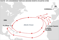
It's part of the North Atlantic Gyre...

gyre.gif

Associated eddies form as well...


NOAA also forecasts the location of the Gulf Stream. Here is the forecast for the Key Largo area as of now:

Coastal Waters Forecast for Hawk Channel from Ocean Reef to Craig Key out to the reef (GMZ042)

Hazardous marine condition(s):

SEAS ARE GIVEN AS SIGNIFICANT WAVE HEIGHT...WHICH IS THE AVERAGE HEIGHT OF THE HIGHEST 1/3 OF THE WAVES. INDIVIDUAL WAVES MAY BE MORE THAN TWICE THE SIGNIFICANT WAVE HEIGHT.

Synopsis...HIGH PRESSURE CENTERED OFF THE SOUTHEAST UNITED STATES COAST WILL CREATE FRESH TO STRONG EAST BREEZES THROUGH THE EARLY AFTERNOON HOURS. THIS HIGH PRESSURE CENTER WILL WEAKEN AND SLIDE SOUTHWARD TONIGHT AND THURSDAY...ALLOWING WINDS AND SEAS TO SUBSIDE THROUGHOUT THE KEYS COASTAL WATERS. GENTLE TO MODERATE BREEZES ARE EXPECTED LATE THIS WEEK THROUGH THE WEEKEND.

THE APPROXIMATE SHOREWARD EDGE OF THE GULF STREAM AS OF MARCH 28...

14 NM S OF DRY TORTUGAS LIGHT...ON LOGGERHEAD KEY. 20 NM S OF COSGROVE SHOAL LIGHT...OFF THE MARQUESAS KEYS. 25 NM S OF SAND KEY LIGHT...OFF KEY WEST. 25 NM S OF LOOE KEY...OFF BIG PINE KEY. 22 NM S OF SOMBRERO KEY LIGHT...OFF MARATHON. 11 NM SE OF ALLIGATOR REEF LIGHT...OFF ISLAMORADA. 6 NM SE OF MOLASSES REEF LIGHT...OFF KEY LARGO. 3 NM E OF CARYSFORT REEF LIGHT...OFF OCEAN REEF.

GULF STREAM INFORMATION COURTESY OF THE NAVAL OCEANOGRAPHIC OFFICE.

This Afternoon...East winds 20 to 25 knots...decreasing to 15 to 20 knots late. Seas 3 to 4 feet. Nearshore waters very rough...becoming choppy late. Isolated showers.

Tonight...East winds 15 to 20 knots early...decreasing to near 15 knots after midnight. Seas 2 to 3 feet. Nearshore waters choppy...becoming a moderate chop late.

Thursday Through Friday...East to southeast winds 10 to 15 knots. Seas around 2 feet. Nearshore waters a light to moderate chop.

Saturday...East to southeast winds 10 to 15 knots. Seas around 2 feet. Nearshore waters a light to moderate chop.

Sunday...Southeast winds 10 to 15 knots. Seas around 2 feet. Nearshore waters a light to moderate chop. Isolated showers.
 
https://www.shearwater.com/products/peregrine/

Back
Top Bottom