Lake looks very low. The visibility though looks great. The river and lower Lake Huron is stirred up pretty good still.
You are using an out of date browser. It may not display this or other websites correctly.
You should upgrade or use an alternative browser.
You should upgrade or use an alternative browser.
Colpoy Bay depths
- Thread starter Jared0425
- Start date
Please register or login
Welcome to ScubaBoard, the world's largest scuba diving community. Registration is not required to read the forums, but we encourage you to join. Joining has its benefits and enables you to participate in the discussions.
Benefits of registering include
- Ability to post and comment on topics and discussions.
- A Free photo gallery to share your dive photos with the world.
- You can make this box go away
patpicos
Contributor
Dove Cedar hill yesterday with that nasty 50-60km wind at surface. Went straight out and took about 13-15 mins to reach 115ft depth. W/o current it would have taken 5-6mins id say. There was a decent current all the way down to 80ft and then it slowed down. The little windmill underwater close to shore was spinning pretty good. Was neat to seat green algae floating by you at decent speed.
As said earlier, the bottom by cedar hill is muddy and rather featureless (I was hoping rocks!)
As said earlier, the bottom by cedar hill is muddy and rather featureless (I was hoping rocks!)
rjk75
Contributor
Patpicos,
Was the water temp above 5C near shore; i.e., 30ft and less?
Was the water temp above 5C near shore; i.e., 30ft and less?
patpicos
Contributor
It was 34f ish throughout.
no thermoclines yet. Again u don't notice em when numb
no thermoclines yet. Again u don't notice em when numb
ScubaSteve
Wow.....what a DB
Cedar Hill was 39° top to bottom yesterday.
Would this wall be located at
https://maps.google.ca/maps?q=44.82...22,-79.706497&sspn=0.133306,0.308647&t=h&z=17
or perhaps
https://maps.google.ca/maps?q=44.81...86,-80.982907&sspn=0.004071,0.009645&t=h&z=17
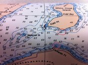
According to my nautical charts, the first one seems to go from 0' (at shore) to ~160' in a matter of 175' or so........to a deepest depth between White Cloud and shore of 250'. The second seems to drop off from 15' to ~110' from 700'-875' from shore.
I am seriously considering finding the means to check these out this year (once I have located the underwater forest on Gunderson Shoal of course ) so your feedback would be much appreciated.
There's a wall off the south side of White Cloud, and a shallow bay on the west side. The wall would be fun to check out.
Would this wall be located at
https://maps.google.ca/maps?q=44.82...22,-79.706497&sspn=0.133306,0.308647&t=h&z=17
or perhaps
https://maps.google.ca/maps?q=44.81...86,-80.982907&sspn=0.004071,0.009645&t=h&z=17
According to my nautical charts, the first one seems to go from 0' (at shore) to ~160' in a matter of 175' or so........to a deepest depth between White Cloud and shore of 250'. The second seems to drop off from 15' to ~110' from 700'-875' from shore.
I am seriously considering finding the means to check these out this year (once I have located the underwater forest on Gunderson Shoal of course
ScubaSteve
Wow.....what a DB
Looks like a steep wall a mile to the west of Cameron Point. Also that shoal says cool dive all over it.
ScubaSteve
Wow.....what a DB
Sorry, I missed these posts Steve. It's the first one, it looked great from the surface two years ago. I'm up for trying it.
The shoal *is* cool, and I'm up for going back.
Sadly I just found out that my only access to a boat is selling it
 . I need to find another boat......I have the coordinates (I think) but no access. The only place that rents boats is in Penetanguishine so that is not even an option.
Similar threads
- Replies
- 25
- Views
- 1,915


