Little boat question

Please register or login

Welcome to ScubaBoard, the world's largest scuba diving community. Registration is not required to read the forums, but we encourage you to join. Joining has its benefits and enables you to participate in the discussions.

Benefits of registering include

  • Ability to post and comment on topics and discussions.
  • A Free photo gallery to share your dive photos with the world.
  • You can make this box go away

Joining is quick and easy. Log in or Register now!

Is the OP 's 15ft Bonita of a similar design to the Boston Whaler?I tried to find the company online but it was not there.
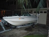
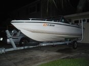
Would like to see a picture of what the OP is intending to go out in.
 
Here it is. Attaching the pic was much easier than it seemed the first time.
 

Attachments

  • boat1.JPG
    boat1.JPG
    53.8 KB · Views: 63
  • boat2.JPG
    boat2.JPG
    42.8 KB · Views: 61
Is the OP 's 15ft Bonita of a similar design to the Boston Whaler?I tried to find the company online but it was not there.
Would like to see a picture of what the OP is intending to go out in.

No.

I had one of these for a bit in college as a fun little ski boat and yes, it is actually a decent little pocket ski boat. It is 14 feet long, we had a 70 horse on it. Yes, it went offshore Destin including to the Liberty ship. Back then it was still a small boat but not that much smaller than others. Not everybody had a triple engine center console, in fact, nobody did that I recall.

boat_030.jpg


My dad had one of these, spent much time in these, nobody ever thought twice about heading out, our had twin 40s. All wood Lyman.

GetImage.jpg


I am sure I would rather have this, commercial series BW ready to do harm:

default.jpg


If it sinks, bring a pool floaty and paddle to the beach, just add to the artificial reef, doing his civic duty.

N
 
Last edited:
Here it is. Attaching the pic was much easier than it seemed the first time.

outboard or inboard/outboard?

if outboard, is the freeboard of the stern full height or much lower?

it it a self bailing cockpit?


on a rough day or having to go though the pass with an offshore wind kicking up waves and an outgoing tide, it'll be a rough ride coming in.
 
Sometimes it is like this (notice the 16 foot Glastron bow rider):

djets_edited.jpg


It is about a ten minute ride to the Bridge Rubble from here, if the seas are more than 3 to six INCHES better stop here.

The buoy outside the Destin pass:

DSCF0426.jpg


On the Liberty Ship, offshore Destin:

DSCF0410.jpg


On the Louise off Henderson Beach:

IMG_0487.jpg


Would you stupid fish please go away, geeez, such lens hams you are, on the Louise deck:

IMG_0466.jpg


Coming back in, just outside the bar and rounding the bouy, waves are stacked up, I had to ride the back of a roller in over the bar therefore no photography occurred beyond this point (my wife is camera-a-phobic when she is hanging on for dear life), I exaggerate a little, seen tons worse, this is nothing but in a 15 foot bow rider it would be more than a little exciting, in fact, you might imitate a submarine:

P6190022.jpg


N
 
Last edited:
Sometimes it is like this (notice the 16 foot Glastron bow rider):

djets_edited.jpg


I'd like to point out to the original poster of this thread, the above pic that Nemrod posted is well inside the pass and also protected by the "finger jetty" that wraps around towards the beach.


It's prob the calmest spot in East Pass and a very popular local shore dive spot. However, when the tide is coming in or out, there is enough current in this location to keep most people from diving there. (or if you do dive during a tidal surge, wear gloves becuase you will have to hold onto rocks the entire time to be able to move.)

just wanting to put it in perspective.
 
LOL, it is only a shore dive if you are not in a boat.

Let me give another dive site INSIDE the bay and north of the Destin Bridge. It is called The Bay Cones:

30-24.680
86-30.754

Next, going east outside the pass, June's Dunes:

Heading of about 85 to 90 degrees for 2.5 miles,

30-22.588
86-27.944

I have not dove the Cones or the June houseboat in a long time so--------??


I notice my secret book of collected Gulf Coast numbers gives for the Louise:

30-22.28
86-25.31

and another note gives:

30-22.291
86-25.320

Heading from pass buoy is 90 degrees for 5.9 miles.

Another that is in the area of the Bridge Rubble is the Elgin Barge:

30-21.249
86-29.760

Located 1.5 miles on 145 degree heading form the buoy.

I have not dove some of these in years so again----???

I don't give hard bottom numbers but there are numerous small ledges about, since nobody dives them----lol---never know. Some light up like a battle ship on side scan, others come and go in the shifting sands in accordance with God's plan.

If you look close, wear your bi-focals, lol, you can see a limestone ledge especially in the right pane:

S00015.jpg


All navigational info is general reference only and I in no way guarantee accuracy and the suitability of any vessel or skipper to reach and return from said spots is between them and the laws of nature.

N
 
Last edited:
I don't give hard bottom numbers but there are numerous small ledges about, since nobody dives them----lol---never know. Some light up like a battle ship on side scan, others come and go in the shifting sands in accordance with God's plan.

N

Lobster holes!

All my numbers are in LORAN C TD's and they don't covert accurately to GPS but I pulled some monster bugs off those ledges.
 
Sorry, accidental post. I found a map resource but decided not to post it here. Don't want to tempt the innocent to much with the siren's song.

N
 
Last edited:
Two more dive spots in the area.

Shark Alley, a small rock bump, have not been there in years, don't know what locals call it if anything, I call it that after I dropped over on it when I was 15, solo, only to be greeted by what at the time I considered to be a large shark, nobody believed me on the boat, sand may have covered it, who knows. We used to bounce this stuff, anything that showed on the sonar, it was my turn to touch bottom, what I found was a big shark and a small ledge or rocky area:

30-22.218
86-29.622

Brown Barge:

30-21.368
86-35.061

I often see a split mark on my two gps units. That and things can move a little or other factors numbers may not be dead on. I usually proceed to a number and then mark it on my plotter. I then circle the area with sonar until I see (hopefully) what I am looking for. Then I hit mark again, I circle back to the mark and get yet a third mark and so on. Once I have an idea of where the object, wreck, ledge, rock runs then then I come back around on my best mark with anchor at ready, idling upwind slowly until on the mark and drop anchor when dead over the mark. Usually the anchor is sitting on whatever it was I was looking for. But from time to time, there is that sinking feeling you get when you arrive on bottom only to be greeted by an expanse of white sand, it happens. If you just blow up and drop anchor on a mark, no matter where you get it from, chances are you will find the sand desert this area is famous for.

N
 
Last edited:
https://www.shearwater.com/products/teric/

Back
Top Bottom