Tropical Storm Paloma

Please register or login

Welcome to ScubaBoard, the world's largest scuba diving community. Registration is not required to read the forums, but we encourage you to join. Joining has its benefits and enables you to participate in the discussions.

Benefits of registering include

  • Ability to post and comment on topics and discussions.
  • A Free photo gallery to share your dive photos with the world.
  • You can make this box go away

Joining is quick and easy. Log in or Register now!

We were scheduled to leave this morning for Grand Cayman and our trip was cancelled yesterday as news of Tropical (now Hurricane) Paloma hit. We were lucky and got our trip rescheduled for Friday Nov. 14th. We didn't even unpack. We can't wait to come and we're praying that the eye of the storm stays more to the East so there isn't too much damage.

Our thoughts and prayers are with all of you out there!!
 
Just confirmed that our flights are cancelled as well and we've rescheduled for an arrival on the 15th. Thanks again for all the updates on the situation there, we'll be praying that there isn't much damage for you guys. Take care!

Laura
 
What the hell?! Five computer models now show Paloma turning back on or after crossing Cuba...?!

From Dr.Masters...
The track forecast
A strong trough of low pressure approaching the U.S. East Coast is pulling Paloma to the north, and this trough should continue to pull the storm northwards and then turn it northeastward by Saturday morning.

282r9g.gif

 
Just a quick note; I have a flight to catch...won't be able to follow-up for awhile.


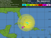
As of Friday AM/midday, it looked like Paloma was going to cross right over Grand Cayman.

By Friday evening, the track was twisting east; looked like the East End was going to get nipped, and then it was going to track right up the north shore (Bloody Bay) of Little Cayman.

As of ~5AM Saturday, it turns out that that twist was stronger than expected; it looks like it is ripping down the southsides of Little Cayman & Cayman Brac; I've plotted the (5AM SAT) storm center location onto Google Map here.

This gives the appearance of it being 5 miles off the south coast, but the track has a 15 mile error bar, so we need to watch the CYB weather gage for more info. As of SAT AM (7 EST), winds have generally been from the North, at 70-100mph; gusts to 110mph. And 6 inches of rain within the last hour(!)

Stormcarib.com will be the place for local reports afterwords.

I'm afraid that this one is going to be a pretty bad one; probably worse than Ivan and at least very comparable to Gilbert. There will also be some that will draw the parallel to the Storm of '32, as it was also an Early November storm and Paloma is hitting on its 76th anniversary.


-hh
 
From Dr.Masters
Hurricane Paloma exploded into a extremely dangerous Category 4 hurricane with 140 mph winds last night as it hammered the Cayman Islands. Paloma now ranks as the second most powerful November hurricane on record, and stands poised to deliver Cuba a devastating blow tonight.

continued
Sounds like Little Cayman and Cayman Brac took is really bad...
 

Attachments

  • Paloma.gif
    Paloma.gif
    34.1 KB · Views: 63
  • Paloma _model.gif
    Paloma _model.gif
    37.6 KB · Views: 45
The early reports that are coming out of the Caymans seem to indicate that Grand Cayman dodged a bullet but just like DandyDon said, Little Cayman and Cayman Brac got pounded. Power down every where and roofs blown off houses. What a tough break for those fine folks but they'll come back strong because they always do. On a positive note, so far there have been no deaths reported. Let's hope it stays that way.

We're all wishing them the best.

BDSC
 
Also good that it didn't veer east into Haiti where rescue efforts are underway to save children trapped in a collapsed school.

None of the computer models agree on where it may go after Cuba...?
 

Back
Top Bottom